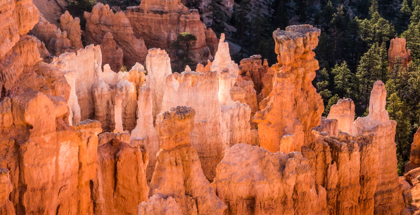
Until we got the Bryce Canyon National Park, Wendy and I thought that Badlands National Park was the weirdest place we’d ever seen. Now, this is the weirdest place we’ve ever seen. The National Park Service describes the area as a “forest of stone,” and it is exactly that.
Mile after mile, thousands of hoodoos, tall rock spires of alternating layers of brilliantly colored rock.
I noted in jest that Badlands could be a set for a grade-B science fiction movie, something like Amazon Women from Venus. It turns out that areas of hoodoos such as these actually have been used to film grade-B science fiction movies (Space Invaders, I think); that’s how other-worldly is the theatrical effect of these formations.
Like the other parks we’ve been to lately, this area is part of the Colorado Plateau, an area of 130,000 square miles that got lifted straight up as a solid block about 7000 feet in a series of uplifts between 65 and 15 million years ago. Then nature started eroding the heck out of the area, apparently with an intent to give us the national parks that have been our stopping points over the past few weeks. Bryce Canyon got its bizarre appearance because this area was a series of lakes prior to the uplift where layer after layer of plain-old mud got deposited. The upper layer turned into “dolostone,” a kind of mud-based rock that is more resistant to erosion that the limestone mud layers beneath it. So, as erosion occurred, the fractured and broken dolostone protected small columns of underlying limestone as other, unprotected areas eroded away. The result is thousands of spires capped by weather-resistant tops. Different amounts of iron the mud-based rock layers result in the horizontal striations seen in the formations.
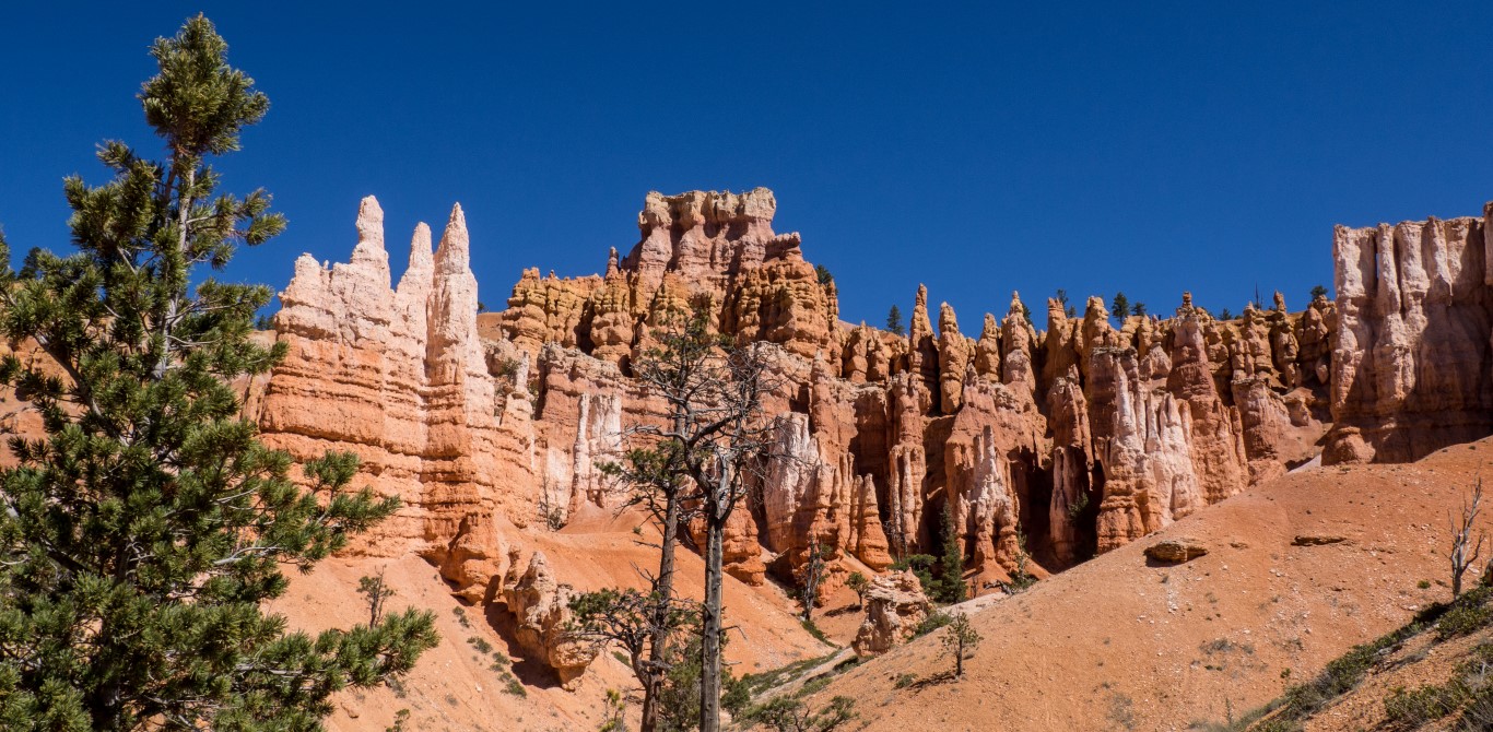
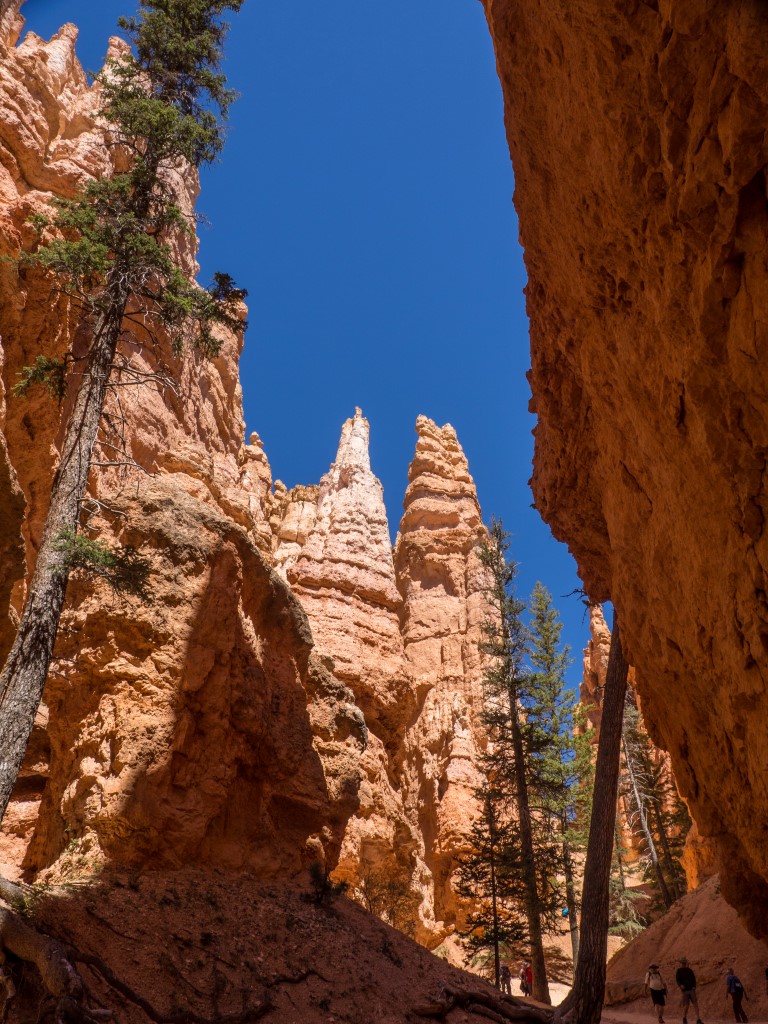
All of that is fascinating if you’re some kind of geology wonk, but it does nothing to describe the effect that hits your eye like a big pizza pie when you actually see it. So, we spent one morning walking from the upper end of the Bryce Canyon “amphitheater” (as the area of hoodoos is called) all the way to the other. And here’s what’s even weirder. In areas, one is just walking through an ordinary pine forest:
Walking along the Rim Trail from Bryce Point at the southern end, moving north towards Sunrise Point. A completely gorgeous hike, just like any place out west, with pine-scented forests and cool, crisp air.
Except that if you stop for a moment and take a look over your shoulder, like at a stop for a picnic, this is the scene:
Seriously? It’s like nature was thinking, “Should this be an ordinary pine forest or a landscape out of Mars? I don’t know. It’s too complicated. Put them both there and see what happens.”
Ebenezer Bryce was once asked to describe the area and his response, in true, understated, Mormon fashion was, “It’s a hell of a place to lose a cow.” Indeed.
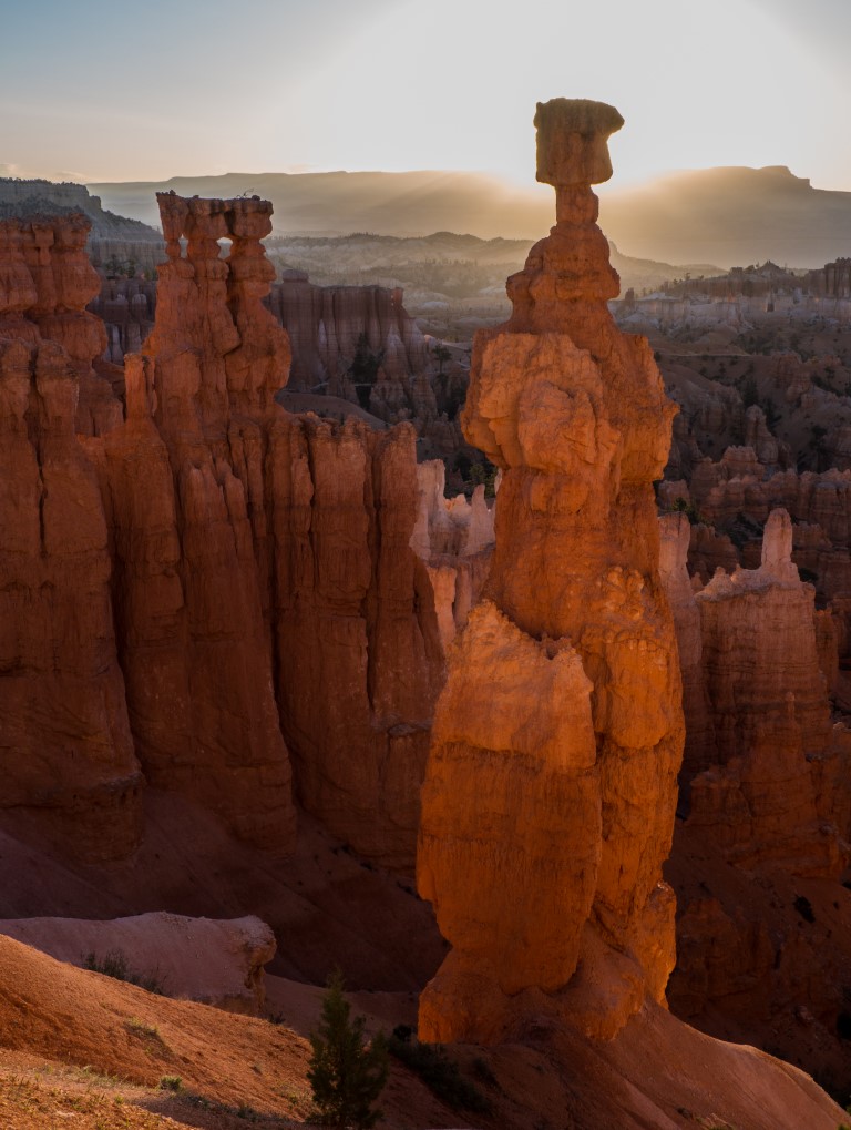
At sunrise and sunset, especially if the sky shines in oranges and reds, the whole canyon lights up. In places, the rocks reflect back on each other and it’s as if the rocks are illuminated from within.
This is at Sunset Point and, believe it or not, the light wasn’t even that great. But as the sun went down, it would bounce off the rocks, sending light in all directions within the formations, with some formations appearing almost translucent.
And if you think these things are weird from the top, you should see them from the bottom! One day we took a hike down into the hoodoo-filled canyon floor, and we were completely awestruck to an equal degree.
About half-way down into the canyon on the Queen’s Garden Trail.Along the Navajo Loop Trail where one can see how the bases of the hoodoos form deep, twisting canyons.
Although the experience at the canyon floor was wonderful, it did present one teensy-weensy, hardly-worth-mentioning problem: we had to get out of the canyon floor. That involved a hike up a trail consisting of 36 switchbacks rising 550 feet. Quite an experience for a couple old geezers!
One thing for sure: this is definitely not a place to let the kids run loose. Even the Park Service has signs everywhere saying, “Dangerous Cliffs … Watch Your Children.” Countless times we heard little boys say something like, “Put me down…” or “Let me go…” and the parental refrain was always, without exception, the exact same words: “No way.”
And I did my usual photo thing, including getting up early one morning to get some sunrise photos:
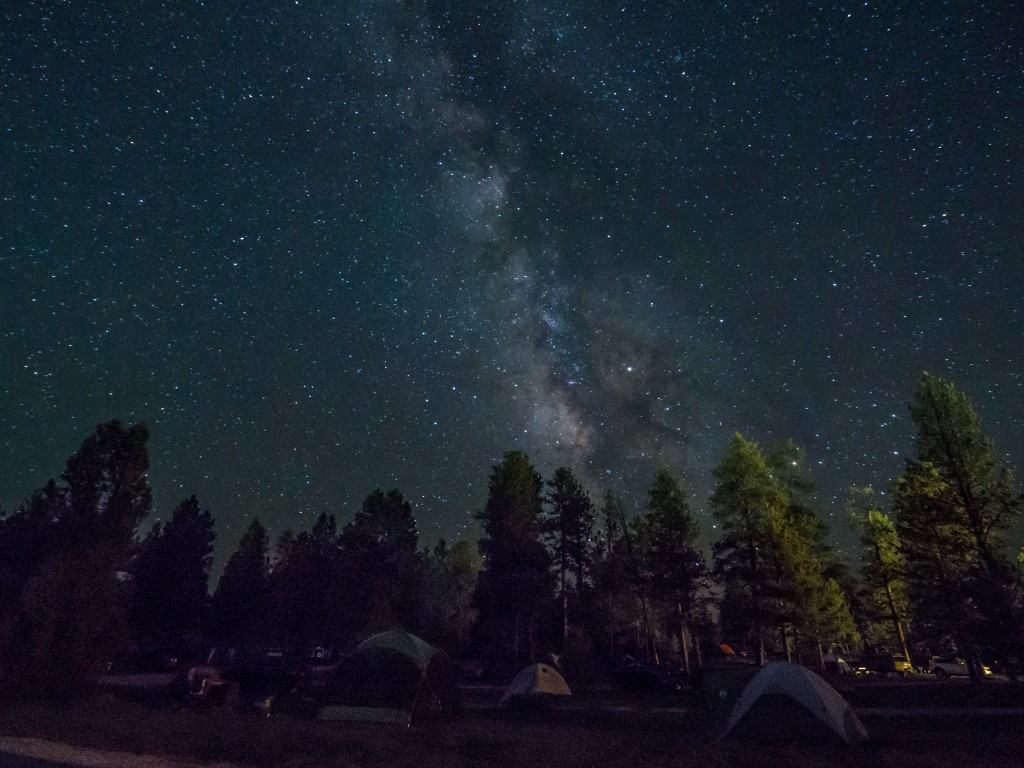
I had to hike down one of the narrow, gravel-covered, winding trails in the dark to get this picture of Thor’s Hammer at sunrise. Don’t tell Wendy, though. She thinks I’m too prone to taking foolish risks and I keep denying it.And a shot of the Milky Way over our campground at about 3:00 a.m. Most of the campers here are young families, camping in tents with a terrifying number of toddlers.
So, we’re kind of stuck. This might be our favorite park so far, at least in terms of visual impact. Or maybe it’s still Arches. Or maybe Canyonlands. Or maybe it will be Zion, where we’re headed next. The only thing we’re sure of at this point is that we’re starting to get worried that the Grand Canyon will be something of a let-down. Think about that for a moment…
OK, traveling around in the west has convinced me that I am definitely going to take some courses in geology. We don’t have geology in the east. We have the Appalachian Mountains, but they’re nothing. Apologists for those mountains claim that millions of years ago the Appalachians were as tall and rugged as the Rockies, but I think they’re just embarrassed by the soft and flabby nature of the Appalachian Mountains so they try to explain away the mountains’ impotence by claiming that the mountains are old. Whatever.
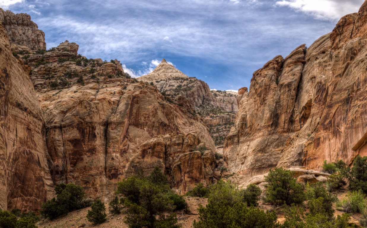
Where was I? Oh yeah, geology. Out here, they have real geology. Manly geology. Capitol Reef National Park‘s claim to fame is a 100-mile long fold in the earth’s crust. Right. The earth’s crust just got all crinkled-up-like, lifted 7000 feet straight up, and now sticks up in the middle of nowhere. Unfortunately, it’s hard to get the full effect of this phenomenon except in an aerial view, so I swiped a picture off the internet:
More of the same thing we keep seeing everywhere out west: unfathomable forces bend and twist the earth, then grind it down, then turn it weird. This is known as the “Waterpocket Fold.”
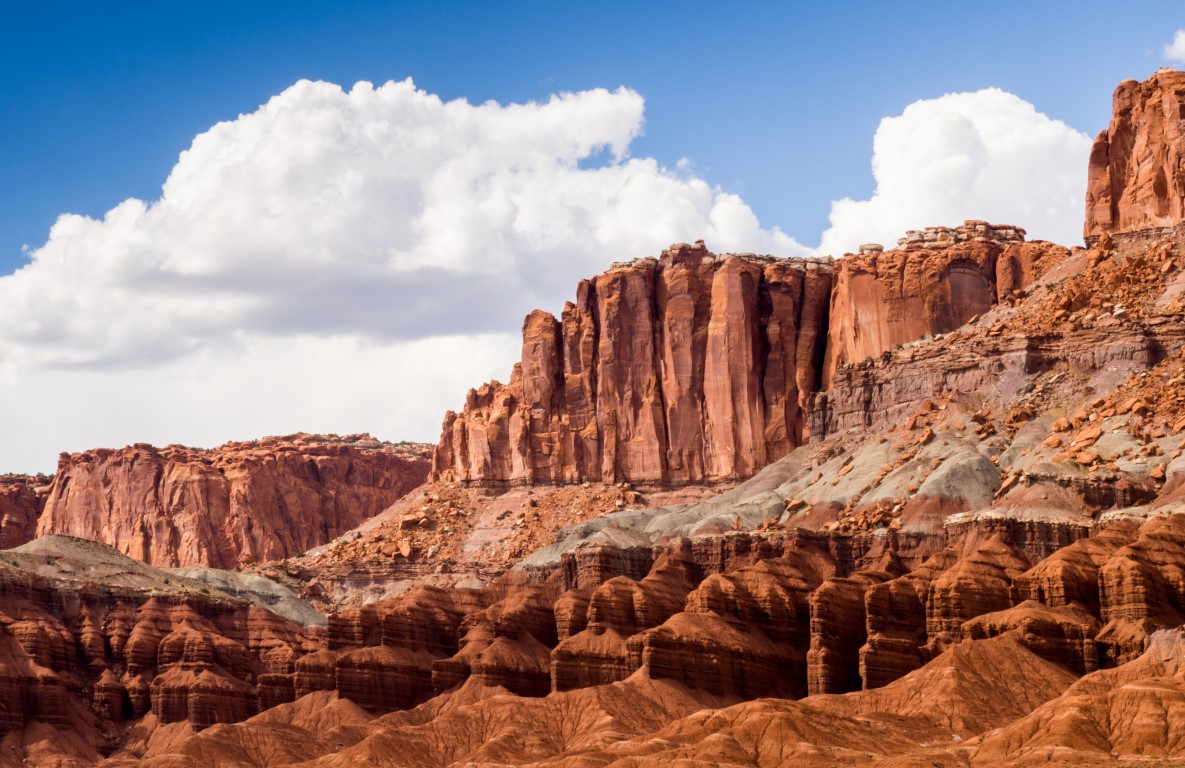
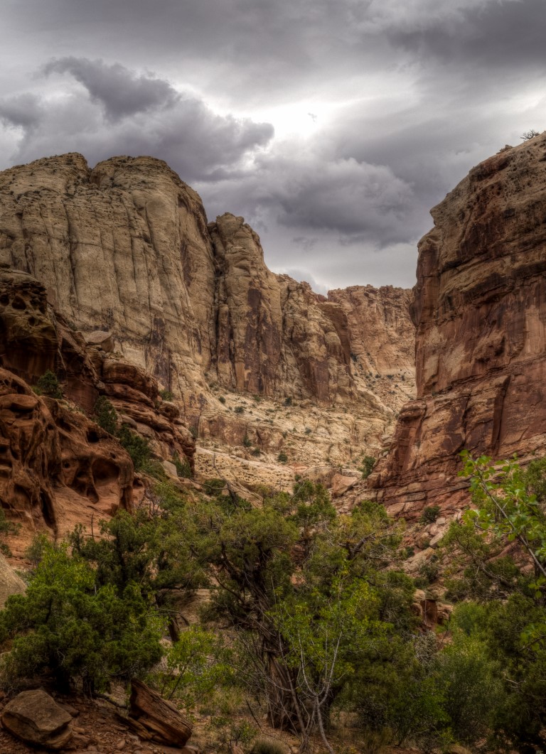
And the geology here is fascinating. As is our practice, we attended a ranger talk, this one on the geology of the area with the eroded cliffs of the Waterpocket Fold as a backdrop.
This was the backdrop for our ranger talk, clearly showing four of the various layers (of a dozen or so) that characterize the Waterpocket Fold.
Most of the interesting areas of the park can be seen along a scenic drive:
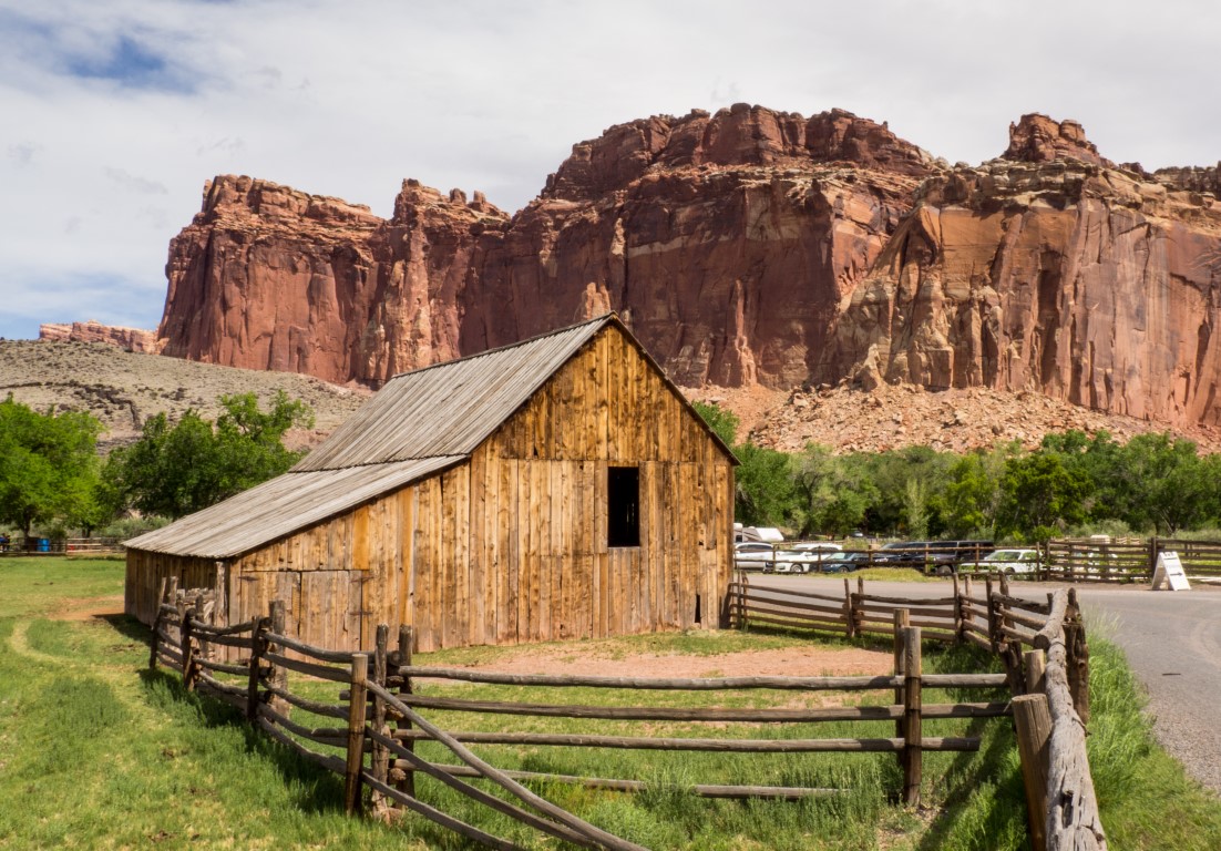
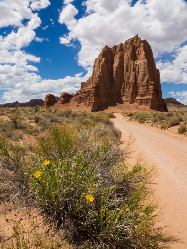
Just one of the many canyons along the 10-mile scenic drive inside the park.Driving up the Capitol Gorge Road. Believe it or not, there’s a road down there. Sometimes, the cliff walls are so close together that the road is barely wide enough for a single car. And until 1962, this was the only road into the area.In the late 19th century, a group of about 10 Mormons settled the area. There was enough water that the Mormons could plant apple, peach, and pear orchards, which still survive to this day. But it’s hard to imagine living here. Mormons must be tough dudes.And, of course, because I’m me, I took off on a five-hour trek down a jeep road (which included intermittent stretches of deep, powdery sand) to get to the Cathedral Valley and snag this picture of the Temple of the Sun.
OK, so the geology is fascinating, but unless you’re a geologist, I’m not sure Capitol Reef is a great vacation spot. We sort of felt like we saw all we wanted to see in a day-and-a-half of touring around. Worth it, but not in the same category as Arches and Canyonlands.
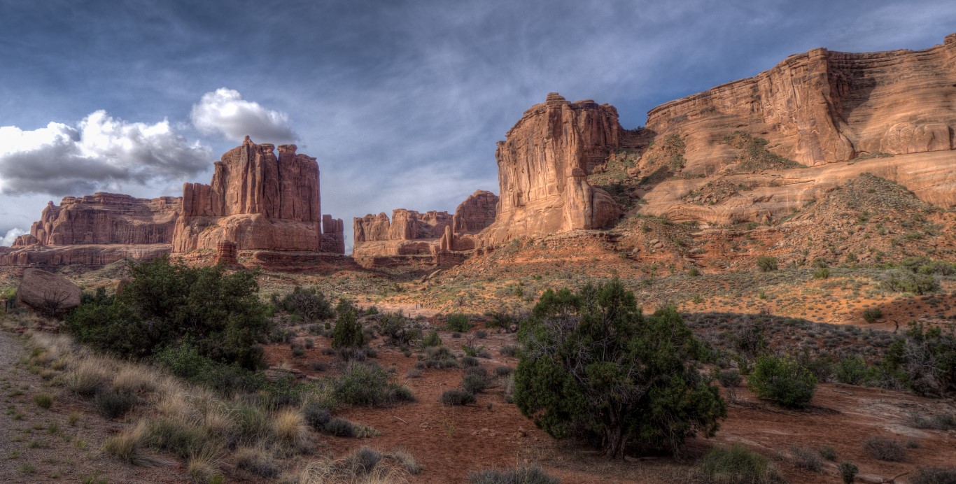
The Islands in the Sky District of Canyonlands National Park is only 13 miles as the crow flies from Arches National Park, but it might as well be 1300 miles. It defies description how two places so close together can be so different. Whereas Arches whacks you in the face with towering, unlikely formations of rock that rise straight up from the surrounding terrain, Canyonlands overwhelms you with deep, unlikely canyons that drop straight down from the surrounding terrain. Arches is an area of specific, localized monuments to the forces of nature; Canyons is an area of vast, endless vistas that testify to the forces of nature. The two places are equal but opposite testaments to nature’s inexorable constructive and destructive forces relentlessly applied to the earth’s surface.
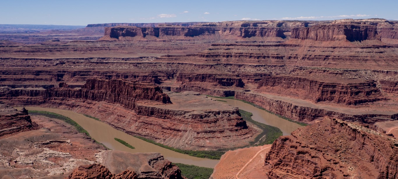
The Canyonlands plateau is an area within the Colorado plateau, the latter encompassing 130,000 square miles of land generally located in the four corners area of Colorado, Utah, Arizona, and New Mexico. While the Pacific and North American plates pushed against each other, one sliding over the other at about two inches per year, and crinkled up the surface of the earth to form the Rocky Mountains, that same movement actually lifted the four corners area straight up as a huge plateau. (I know, I know — how can one lift up a piece of rock 130,000 square miles big and tens of thousands of feet deep? That’s just one of an infinity of incomprehensible realities in this area.) Then, just as nature created the expansive, flat area, it began wearing it down. The top 4000 feet of the plateau has already been worn completely away by water and wind. Where rivers flow through the area, they wear it down even further. Here in Canyonlands, the river canyons are about 1400 feet deep.
This picture was actually taken at Dead Horse Point State Park, which abuts Canyonlands. The park has actually been used in many movies as a surrogate for the Grand Canyon because (1) filming here is easier than on federal land and (2) at least in the eyes of the State of Utah, it’s actually more beautiful. Utah formed the first “film commission” in the United States back in the early 20th century and has gone out of its way to accommodate the movie industry ever since.
We spent several days here, not nearly enough time, and did our usual activities: hikes, picnics, and ranger talks. As we were doing all that, completely enjoying everything about this place, we wondered whether this park would be a good place to bring young children. Definitely not. There are far too many precipitous drop-offs and even a moment of inattention could have tragic consequences, although in reality a child would hit a ledge about 400 feet down rather than dropping all the way to the canyon floor. Still, for most parents, that difference probably wouldn’t matter.
Hiking along the Colorado River rim, on our way to a beautiful picnic spot. (Wendy calls this spot “Monty Python’s Castle.”)One hike worth noting was to Upheaval Dome. Scientists don’t know if this crater with strange green rock in the middle represents a collapsed salt dome or the impact of a huge meteor, although the latter possibility is the current favorite. If it were a meteor, it hit 25 million years, was 1/3 of a mile wide, and hit the ground with the force of a nuclear explosion. Now that would be fun.
We also lucked out and stumbled into an evening “star party” hosted jointly by rangers from Arches, Canyonlands, and Dead Horse Point State Park. The rangers brought six telescopes, enough that the 50 or so people in attendance were not hurried at all. We saw Jupiter, including that “storm” (like a hurricane, I’m told) that’s been raging for 300 years, the “ring nebula” (the circle of dust and gas left over when a star exploded!), and (my favorite) a spiral galaxy. And, of course, because the skies are so dark and the air is so clear, we were treated to the sight of the Milky Way rising before us.
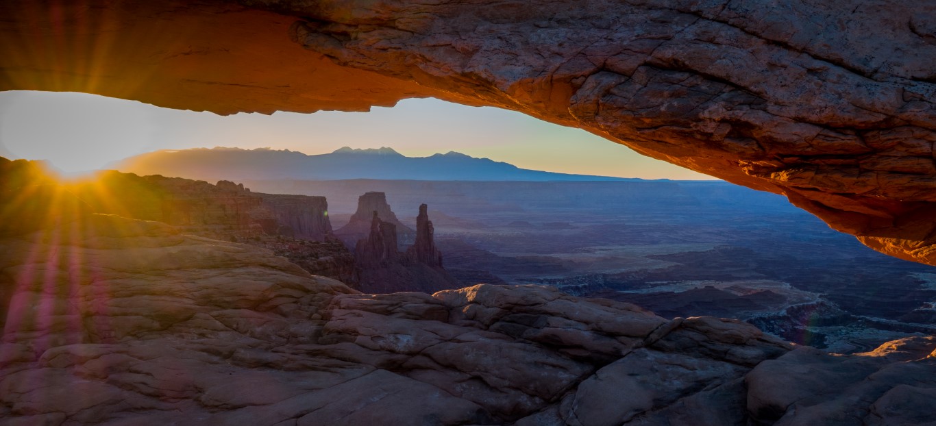
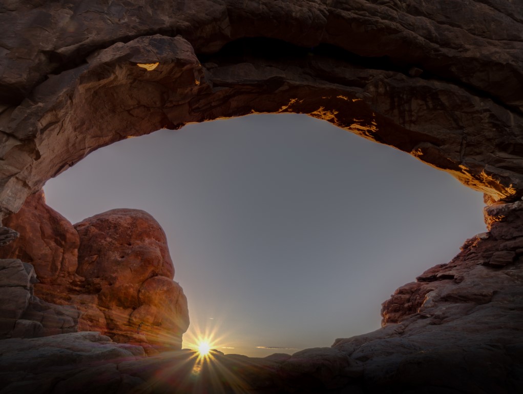
And I was able to get up at 3:00 a.m., again, actually for the third time in the past week, to travel off to a special photo location and snag a picture of sunrise at Mesa Arch. That shot is something of an icon for the park, and is on the bucket list of most serious photographers.
One of the classic, iconic views of sunrise at Canyonlands as seen through Mesa Arch, with the Colorado River canyon and several spires visible in the background. I arrived at the arch at 4:50 a.m., over an hour before sunrise. There were already six photographers lined up, tripod-to-tripod, when I got there. At T-minus-30 minutes, the number had grown to about 30. And then, believe it or not, a tour bus of 30 Asian photographers showed up, which made for quite an experience when the sun finally popped up, with dozens of shutters all clicking in rapid succession. In any event, more pictures of the Mesa Arch sunrise are on the photo albums page.
We ran out of time and did not get to do all of the hikes on the list of recommendations, and we didn’t get to see the other two units of the park at all. But still, this was a dramatic and unforgettable place.
First, the good news. Despite the challenges faced by the park, as described below, not a bit of that detracted from our experience here in the slightest. This place is wonderful.
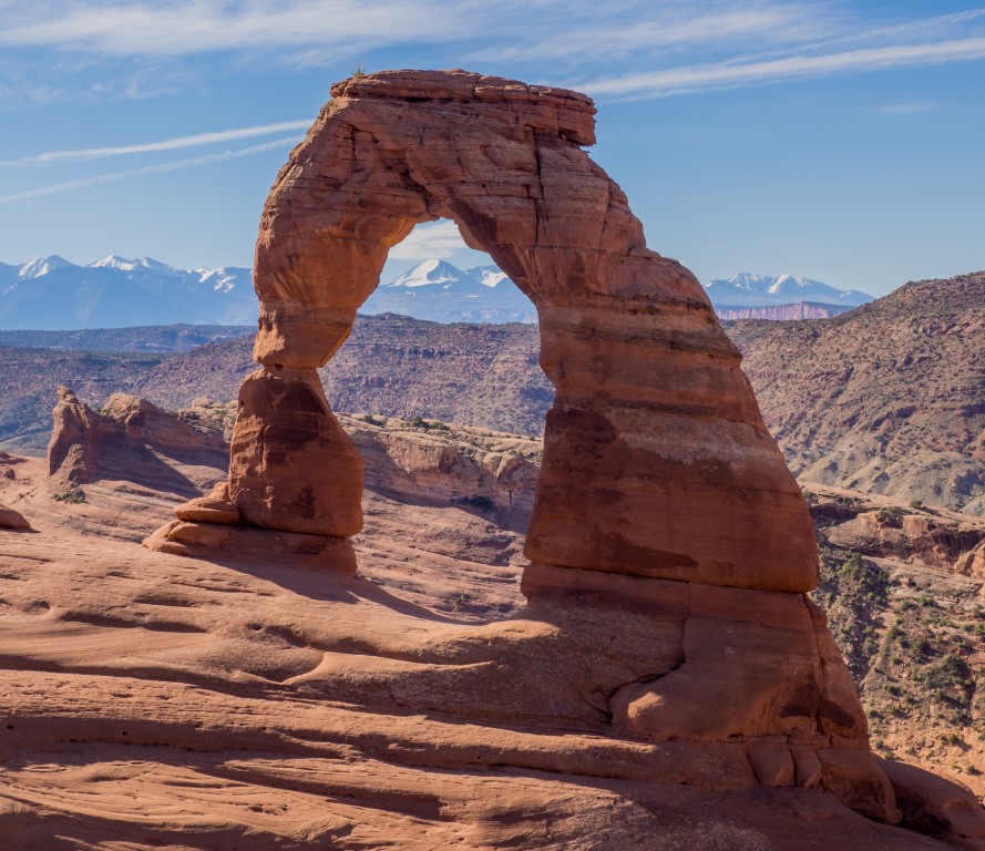
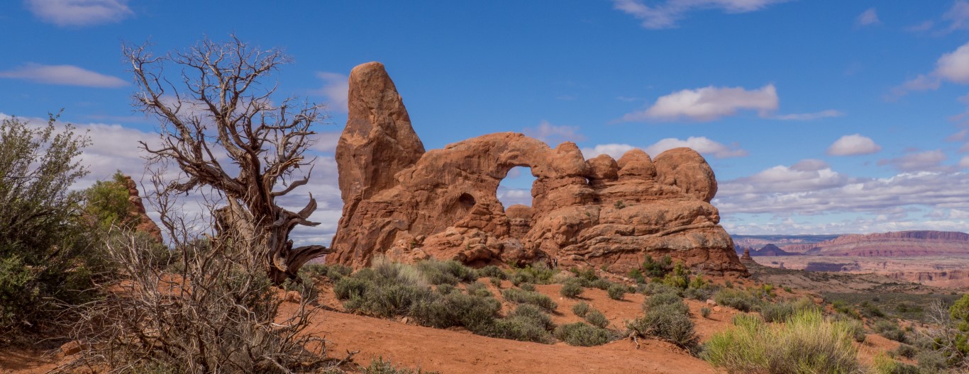
Delicate Arch, the iconic symbol for Arches National Park. And the very same arch that appears on Utah license plates as the symbol for Utah. And probably the one arch that comes to mind for everyone when they think of this park, whether they’ve been here or not.
Arches, as one might expect from the name, has thousands of arches. Over 2000 to be precise. More than anywhere on earth. The explanations for how these arches came to be was never completely clear, but I think it’s something like this. This whole area used to be an ocean that accumulated sand and sediment. Then it dried out. Then it was a lake. More buildup. Then it dried out. Then a swamp. Then dry again. Then a lake. Then dry. Then an ocean again. And so on for dozens of epochs, leaving dozens of layers of rock made up of varying kinds of stuff. Then the whole area got lifted up as part of the Colorado Plateau and started getting worn down by water. As rainfall would hit the rock, it would seep in and in some cases it would hit a layer that was less permeable, so the water would move sideways. As it did, it eroded the rock along the horizontal layer, leaving a layer of intact rock above it. Over time, it wore out the whole kabob, leaving a hole with rock above it. Presto change-o, an arch. This area just happens to have the right combination of layers with the right permeabilities to lead to arches everywhere. Other formations occurred in similar ways. Sometimes there’d be a little clump of really impermeable rock, and everything around it would get worn down. Zippity-doo-dah, a spire. Or sometimes a sliver of impermeable material and abracadabra, a fin. Or a big area, and you get a butte. (I’m pretty sure that if a ranger read this, he’d throw up in his Smokey-the-Bear hat, but too bad. That’s close enough for this story.)
So we spent several days just exploring this fascinating little area of bizarre geology.
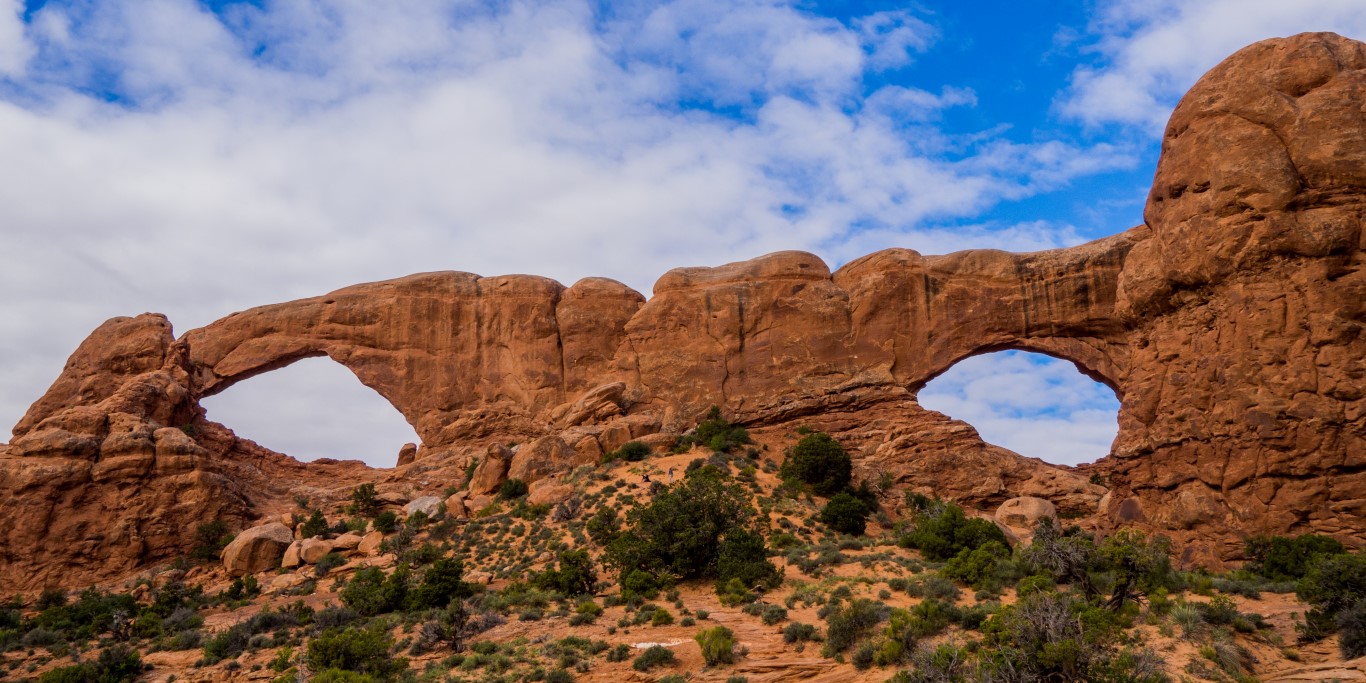
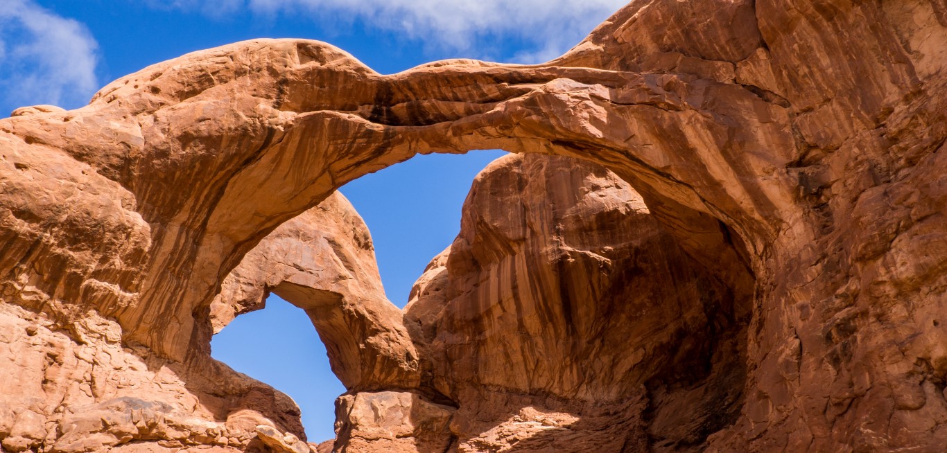
“The Windows,” a pair of arches. On the South Window (the one to the right), you can plainly see a layer of rock that’s been worn away and that is different than the layers above and below it.Turret Arch. Note that area being worn away just to the left of the hole. That’s an arch in progress. Come back in a few million years, and there will be an arch there, although the span over the current arch may be gone.“Double Arch,” again with a plainly visible pocket being eroded below the right side of the front arch. Maybe someday this will be renamed “Triple Arch.”
You get the idea. But it’s not just arches. It seems that everywhere one turns, there’s another oddity caused by erosion in this area of particularly malleable layers of different kinds of rock.
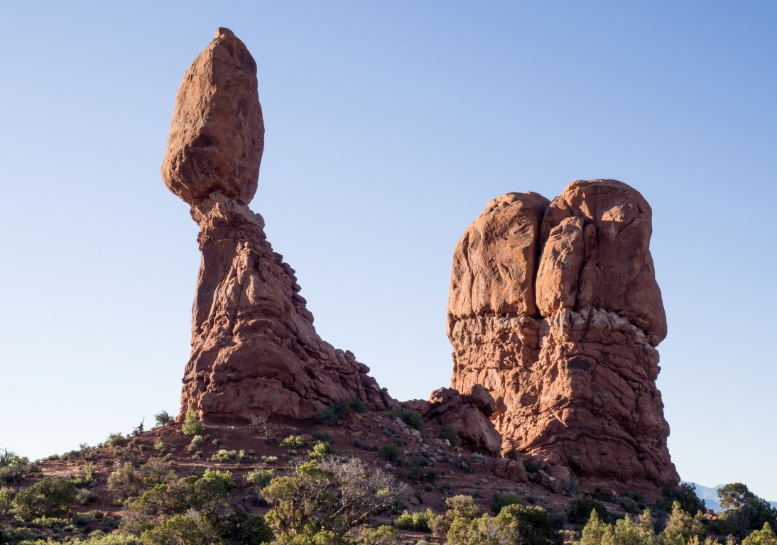
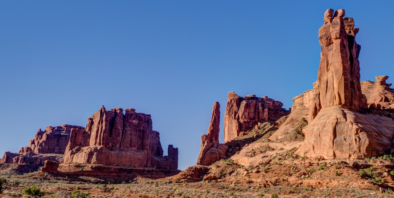
Seriously? This is called “Balanced Rock,” but while it may be balanced now, I’m pretty sure that in the blink of a geological eye, that sucker is coming down.Spires and buttes and fins, oh my. One of the fun aspects of the park are the names they give to the formations. The three spires on the right, each with a rock perched on top, all angled as if huddling together, is called “The Three Gossips.”
And sometimes this place is just unspeakably beautiful.
And, because I’m me, I did do my thing of getting up at 3:00 a.m. one morning and running over to get a shot of one of the arches (the North Window in this case) at sunrise.
They’re not visible in this photograph, but just before sunrise about six or eight people wandered up, most of them not even photographers, and sat here at the arch just to watch the magic of the rocks turning bright orange as the sun climbed above the horizon.
So we had a great time at this strange and beautiful place. We did several hikes, attended a really great ranger-guided walk, all had several picnics, all the usual things, just in a place that is anything but usual.
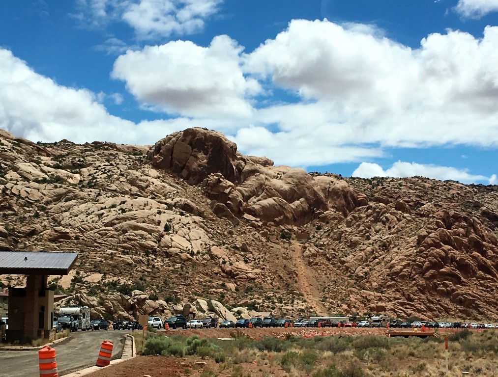
But now for the bad news. Arches National Park is seriously overloaded. I mean like clogged-up, choking-on-itself, loved-to-death overloaded.
A L-O-N-G line of cars, nearly backing up onto US-191, waiting to get into Arches, and this was on a weekday. I bet it took an hour to get to the entrance station.
The problem isn’t the number of visitors, at least not in an absolute sense. Last year, Arches had about 1.6 million visitors, which isn’t large compared to other western parks like Grand Canyon (6.0 million visitors), Yellowstone (4.3 million), Grand Tetons (3.3 million), or even Glacier (2.9 million). The problem, at least as it appears to me, is that there are darn few places for those 1.6 million people to go. The result is that they congregate at a few locations, overwhelming the parking lots, turning the trails into something like urban sidewalks, and destroying the wildness of the place that presumably most of the visitors came to experience.
And the effect is compounded here by three factors: First, Arches is rebuilding its entire road network, and the park was closed Sunday through Thursday from 7:00 pm to 7:00 am. The upper end of the park, including the area around the famous Landscape Arch, is closed entirely. Second, there is a surplus of rental Class-C motorhomes like we have never seen. Hundreds, maybe thousands of them. And because the RV parking spaces are often filled with cars who couldn’t find anywhere else to park, the RVs park in the car areas, taking up 3 or 4 spaces, and the whole thing is a vicious circle. Finally, there seems to an unusual number of tour buses. At the Windows/Turret arches area, for example, there were FOUR (that’s right, count ’em, four) tour buses dumping people into a teeny, 100-yard path to the overlook. Plus, most of them were French, which made a bad situation even worse.
I understand that NPS is currently considering a management plan under which people, at least groups of people, will have to stake out a reservation slot to enter the park. That’s a terrible solution, but maybe better than the current situation.
As I said at the outset, the crowds weren’t really a problem for us and didn’t interfere with our enjoyment of the place. We usually get to where we going early in the day, and we head into the back country where there are fewer people. (Although here, perhaps due to a higher-than-normal proportion of fit, young people (dang them), even the trails had more people than we’re used to seeing. But, as you can see from my pictures, I was always able to capture the scene I wanted with no people in the frame, so things were never that bad.) So, it was a great stop for us despite the crowds. Combined with our excursions to Canyonlands (see the accompanying post), we’ll remember this place for a long time.
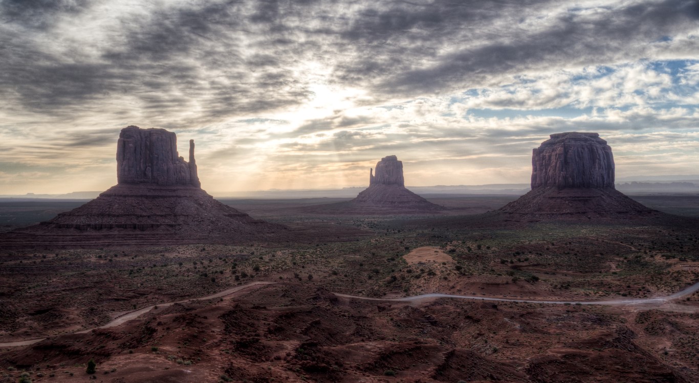
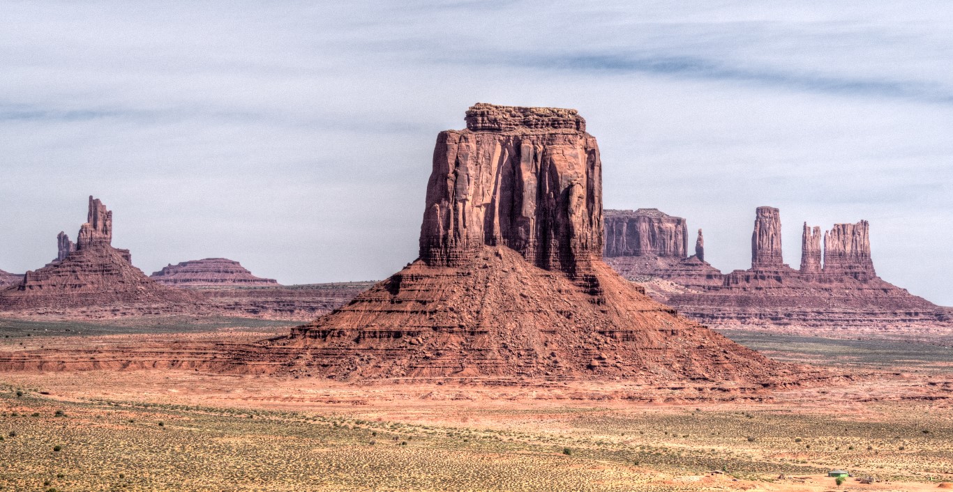
If you’ve ever seen an old Western, you’ve seen Monument Valley.
Just one of dozens of films that were filmed in Monument Valley, many directed by John Ford, including Stagecoach and The Searchers. Other films made here include: Easy Rider, Forrest Gump, The Eiger Sanction, 2001: A Space Odyssey, National Lampoon’s Vacation, Thelma & Louise, Mission Impossible 2, and The Lone Ranger. Plus hundreds of TV shows and advertisements.
[On edit: In a remarkable coincidence, Volkswagen has a new commercial that not only features a few clips from Monument Valley, it expresses in a very heartrending way why road trips have always mattered so much to our family. It’s worth watching here: https://www.youtube.com/watch?v=rpq4NXtokNU.]
But what made Monument Valley a special stop for me was not its connection to the film industry, but its unbelievably photogenic quality. So, with a hall pass from Wendy, I set off at 3:00 a.m., drove several hundred miles to Monument Valley (getting lost twice in the process, but that’s another story), paid the $20 to enter the “Navajo Tribal Park,” and spent several hours just taking picture in this magical place. Below are some of my favorites.
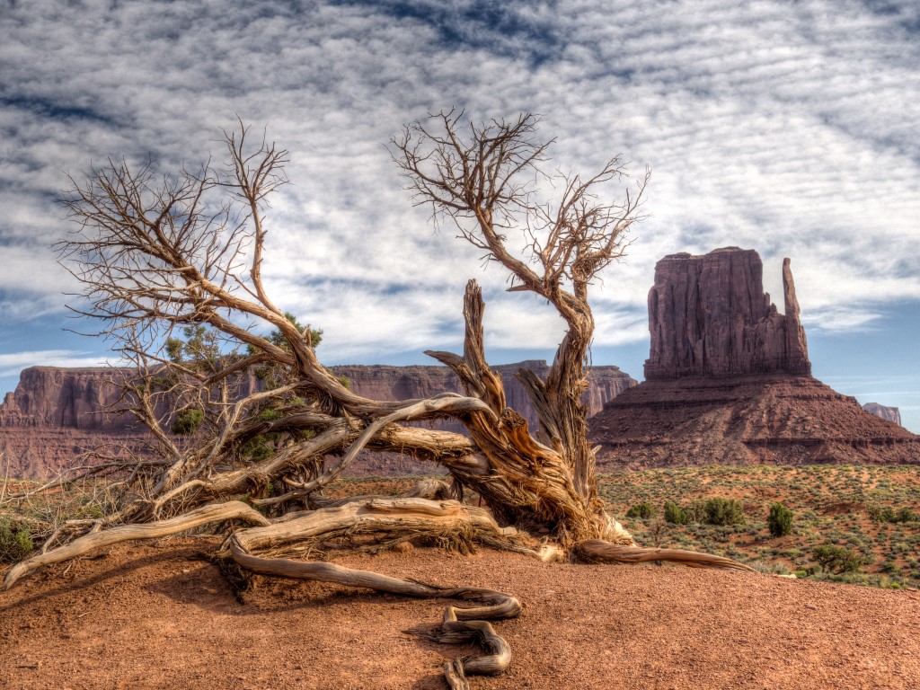
Even though I got lost twice, I still arrived an hour before the drive opened, so I went up to the hotel, had a buffet breakfast, and snagged this picture sitting on the hotel balcony. Visible here are East Mitten and West Mitten (notice the shapes–they do look like mittens) and Merrick Butte.Everything about the area is photogenic, even the dead trees.The view from what is called “John Ford Point” because it is the landscape seen in so many Western movies.
We’ve always loved southwest Colorado, but the family’s first exposure to the area came sans moi back in 1988 when Wendy, her dad, and the three kids made a 6-week trip, zig-zagging cross-country to Grand Tetons where I met up with them. I’m catching up with their experience only now, nearly thirty years later, checking off Fort Davis, Carlsbad Caverns, and White Sands. And now it’s southwest Colorado.
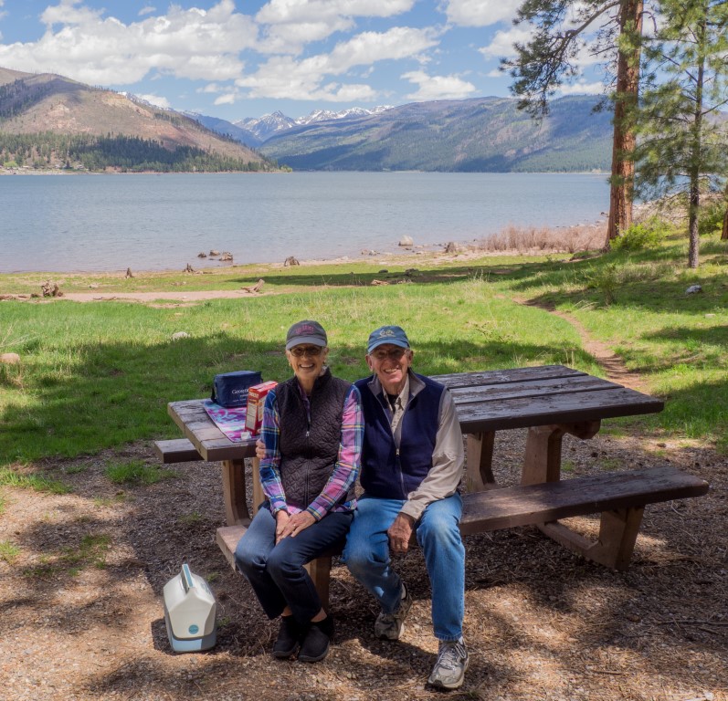
Their base of operations for the area was a reservoir 18 miles from Durango, Vallecito Lake. At 7800 feet, it’s the highest such lake in Colorado, and is situated in an unbelievably picturesque valley. Our mission: find the camp site where the family stayed 29 years ago. Success:
The very spot where the family camped back in 1988. Unfortunately, a fire hit the area in 2002 and it hasn’t recovered yet. And the former campground is now day-use only. But it provided a perfect place for a picnic, for Wendy to relive a trip of a lifetime, and for me to share vicariously in the camping experience of our little tykes.
There are many stories attending the stay at Lake Vallecito (Jennifer coming down with something, the boys converting a log in the freezing cold water into a makeshift raft, Cliff celebrating his 10th birthday, Robert getting his finger stuck in a Coke can) (although consensus seems to be emerging that the finger-in-a-can event actually happened at Fort Davis), but the story that gets the most play involves Cliff standing motionless in the field, like the human equivalent of a Great Blue Heron, with his arm cocked and spring loaded, until bam! he snatched a field mouse out of the grass. Funny how in a beautiful place like this, every time one mentions Lake Vallecito, someone immediately chimes in with, “Isn’t that where Cliff caught the field mouse?”
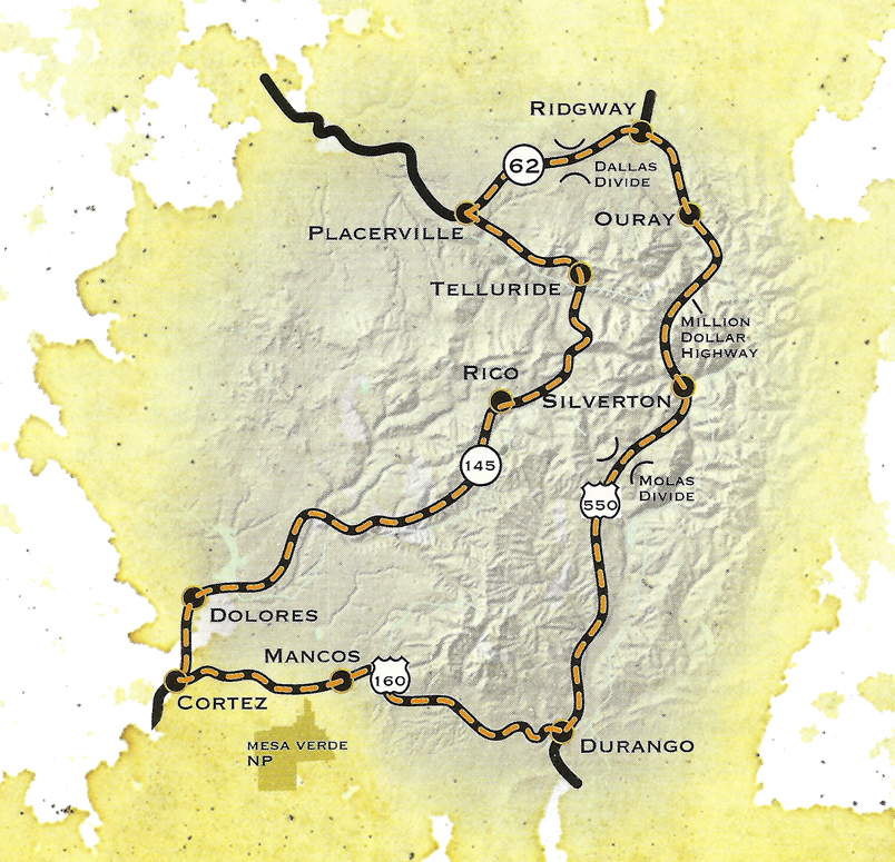
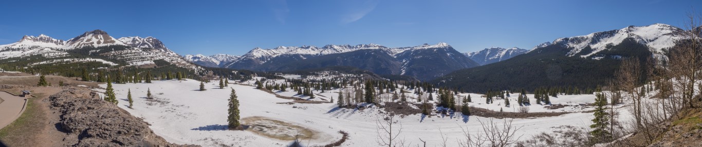
The next day, it was off to drive the San Juan Skyway, a 236-mile designated scenic drive that forms a loop around the San Juan mountains in southwestern Colorado. That range is the largest mountain range in Colorado and has 19 peaks above 13,000 feet. Even in mid-May, the upper portions of the drive were covered in snow.
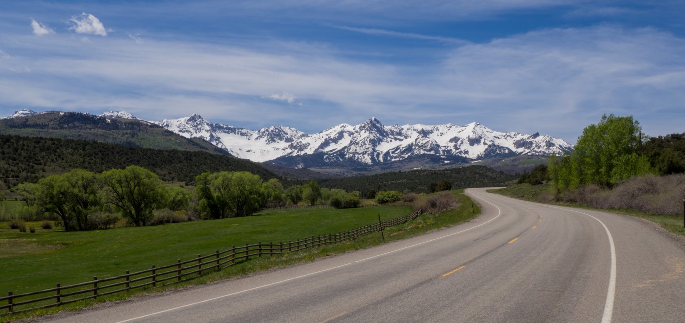
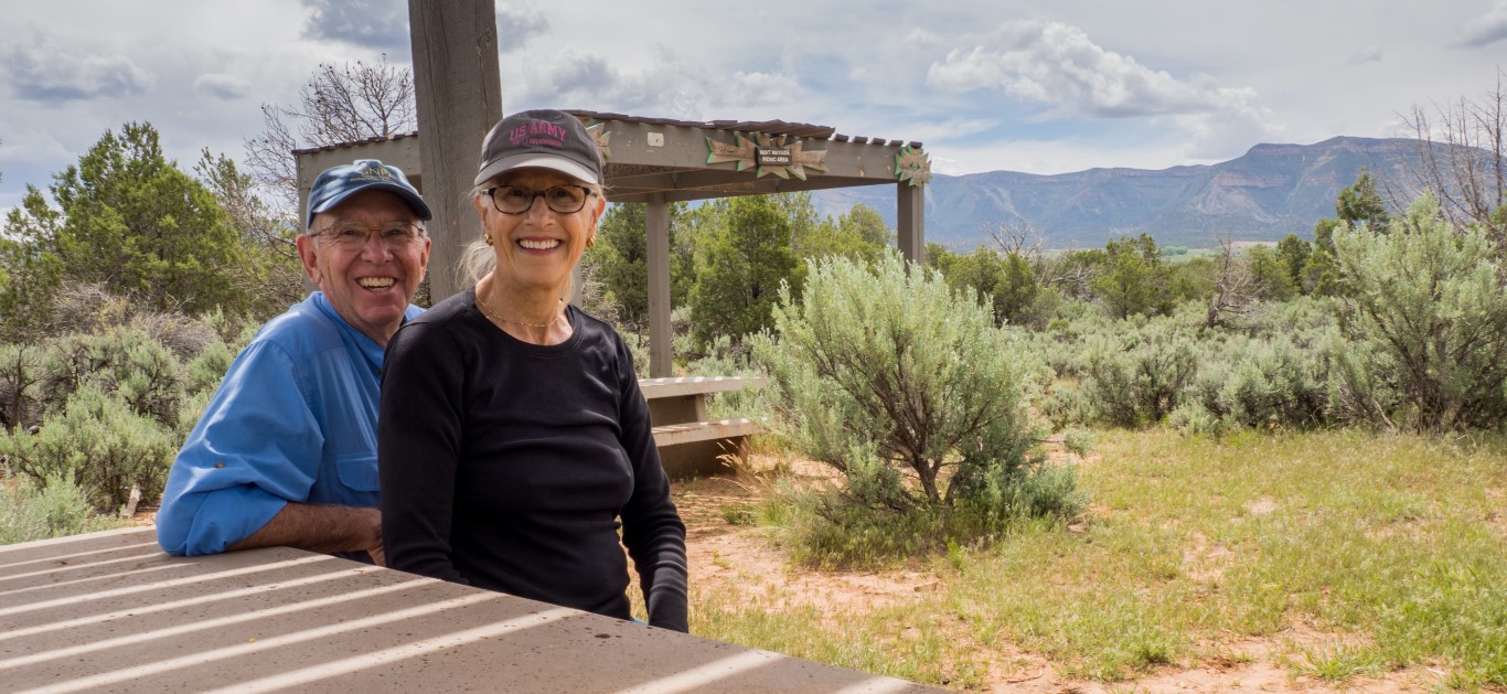
The key features of the San Juan Skyway. Durango, Silverton, Ouray, and Telluride are all now world-famous tourist destinations. We started at the lower left corner at our campground at Mesa Verde National Park.We made at a quick stop at Molas Pass (10,910 feet high), about half-way between Durango and Silverton.On the north side of the skyway, just past Ridgway, the road passes through gorgeous ranch country, although the peaks of the San Juan mountains are never out of view.
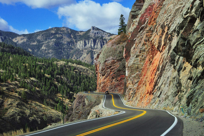
But the highlight/lowlight of the route, without a doubt, is the famous/infamous “million dollar highway,” a terrifying stretch of “road” between Silverton and Ouray, famous not only because it is narrow (barely wide enough for two cars) and twisty, but because it has no shoulders and no guardrails, and has a rock face crowding one side and a thousand-foot sheer cliff along the other. If that description doesn’t scare the bejeezus out of you, perhaps you should consider that the road figures prominently on the list of the world’s most dangerous roads: Dangerous Roads.
This is not fake. It’s insane. There are places where the speed limit is 10 mph and no one “speeds” through those sections. Most of the passengers have to close their eyes rather than look over the edge. Even a new car’s “lane departure warning” wouldn’t help much, except that it would give you something to listen to as you plunged to a certain death.
Hard to believe, but it was a great day. After seven hours on the road, though, we were ready for a rest.
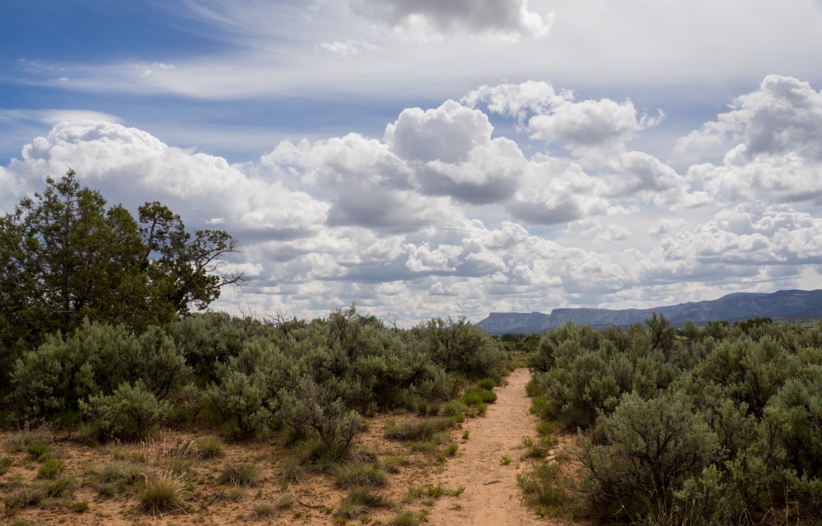
One other thing we did in the Four Corners area: We asked the clerk at the campground what was a fun thing to do locally and she suggested Hawkins Preserve. This seems to be a recurrent theme in our travels: small, locally funded nature preserves that are well done, completely enjoyable, and turn out to be surprising highlights of the trip. This preserve had a network of trails, maybe 4 or 5 miles total, with a wonderful picnic area in the middle.
The preserve actually had four separate environments, ranging from Juniper-Pinyon Pine forests to deep riverbed canyons. And it was a beautiful day.It’s reassuring to know that many communities provide great places to relax and rejuvenate (aided by a picnic lunch), even though such places never show up on the radar of most travel plans.
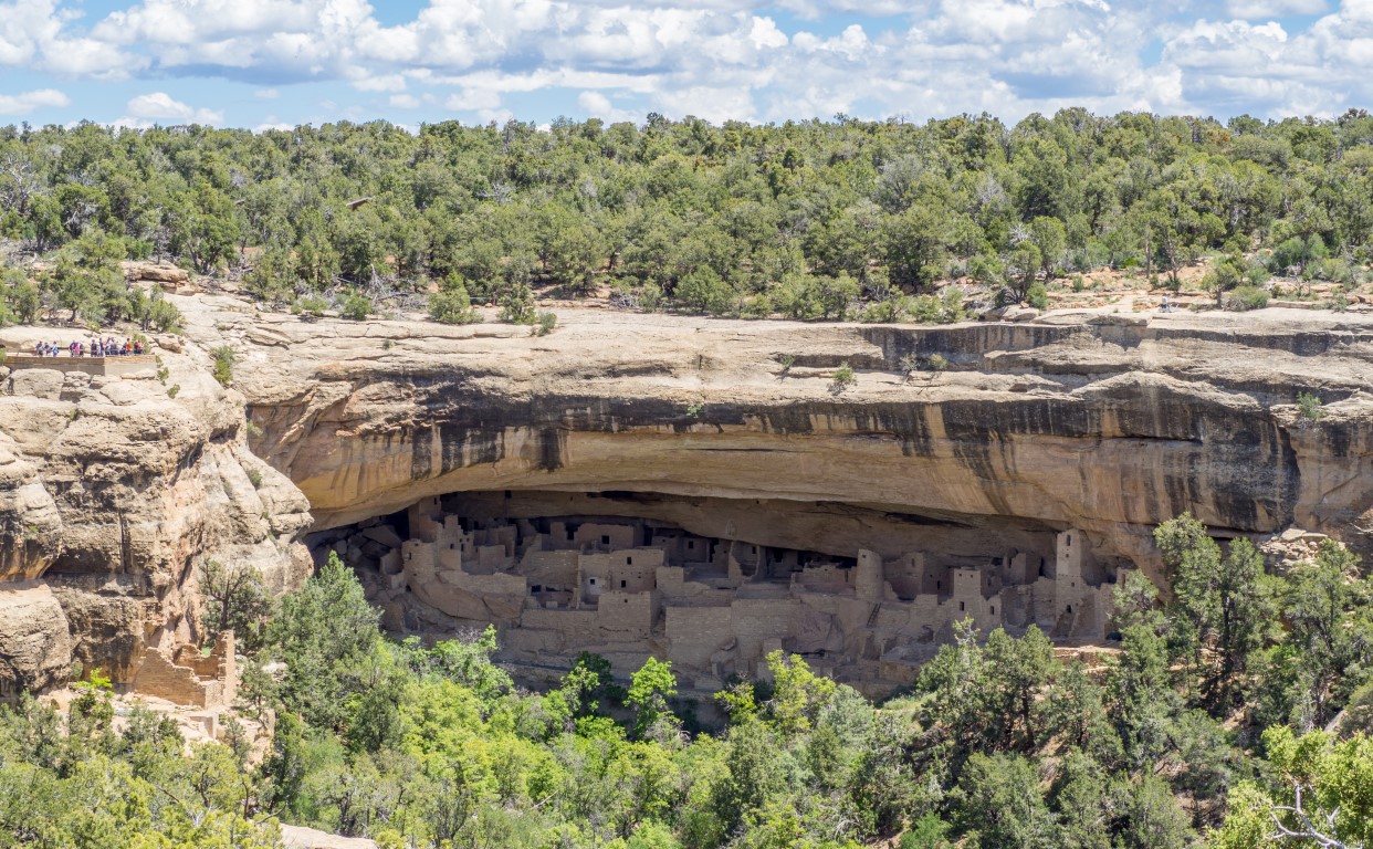
Wendy and I have both been to this national park several times, and it’s not one of our favorites. I’m not sure I know why Mesa Verde even is a national park, as opposed to, for example, a National Historic Site.
To be sure, it is interesting in its own right. Thousands of people once lived in over 600 cliff dwellings, most of them hidden under the overhangs of the canyons cut into the mesa. No one even knew this whole series of habitations was even here until it was discovered by some (probably drunk) cowboys in the 1800s! Everyone ought to see this place, or similar cliff dwellings, once. But once is enough.
This area was occupied from AD 700-1300 by “Ancient Pueblo peoples” (They used to be called “Anasazi Indians”–I assume there’s some political significance to the change), although they lived on top of the mesas for most of that period, living in the cliff dwellings for only the last 75-100 years.
And there are some interesting footnotes to the story. For example, these dwellings were abandoned around 1300, apparently because the Anasazi completely depleted the resources of the area (so much for the Noble Indian living in perfect, sustainable harmony with nature), perhaps in part because of a 24-year severe drought (so much for “climate change” being a new thing caused by nasty coal-burning power plants). But it’s basically just an area of ruins and decayed buildings of a culture that suffered an economic collapse and couldn’t adjust, sort of like making modern-day Detroit a national park.
And (good news for the family reputation), I did avoid getting in an argument with the ranger. When he commented that the Hopi Indians are having a hard time getting the young people to stay on the reservation, making baskets and doing chants to the spirits in the dirt pile, instead of moving to California, going to Stanford, getting a degree in computer science, working for Google, advancing human knowledge, and providing a good life for themselves and their families, how sad, I resisted the urge to offer the counterargument and instead smiled politely and concluded in my mind the ranger must be a total dipstick.
So, we canceled the trip to Blanding (which would have offered more of the same, plus side trips to see ancient Indian petroglyphs, which look a lot like a child’s stick figures, except not quite good enough to be taped to the refrigerator) and will explore southwest Colorado instead. Further posts to follow.
The stop in Tucson was supposed to be a layover to get some work done on ACE, see Wendy’s sister, Susan, and her husband, Terry, see a couple local sights, and basically gear up for the next phase of the trip. Ho-hum. No big deal. It turned out to be a wonderful and memorable stop, maybe even the best of the whole trip. Here’s why. (There’s so much to recount that this is going to take a while. Sorry.)
Things started off with Susan and Terry inviting us to attend their annual Cinco de Mayo party, held this year on Cuatro de Mayo, and attended by some sixty-odd friends and neighbors. (You can read “sixty-odd” with or without the hyphen and I think it works.) We had a great time, wonderful people, great food, and Margaritas made with some orange liqueur that, unfortunately, made them way too easy to drink.
In planning for the trip, we mentioned to Susan and Terry that, oh by the way, we really like Mexican food, so they arranged a series of dinners at Mexican restaurants, each one better than the one before. Mi Tierra, near Susan’s home, was very good; Guadalajara in Oro Valley was, in my view, even better; but what topped el pastel was Elvira’s (no, not named after either the Mistress of the Dark or the song by the Oak Ridge Boys) in downtown Tucson. That last stop was a gourmet restaurant, with a posh, modern décor, and with a menu featuring foods in Mexico City-style, including five different types of molé, with each of our dinners memorable for both their preparation and their presentation. What a treat.
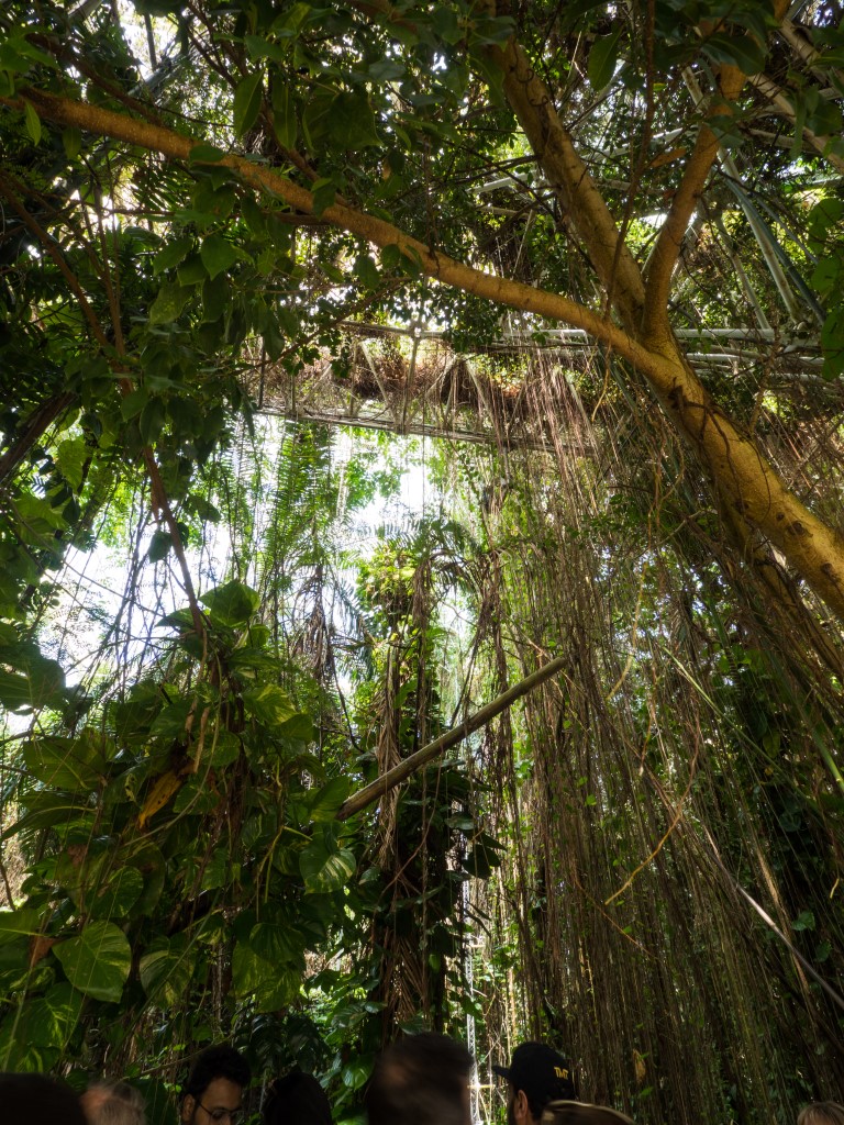
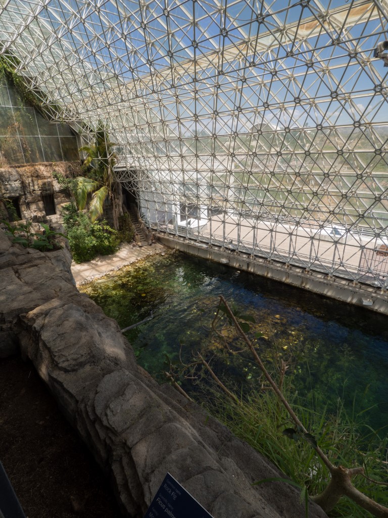
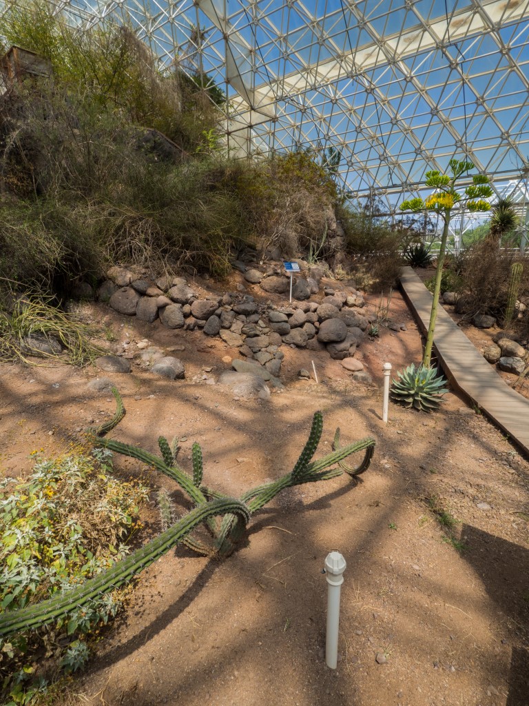
Susan also arranged a trip to “Biosphere 2.” For those of you who don’t remember it, the original “biosphere” experiment was an attempt back in 1991 to seal up eight people in a huge, self-contained structure where they would live for two years, producing their own food, using plants to produce oxygen, recycling waste to grow the plants, blah blah blah. It was sort of like the grown-up version of those terrariums you made as a kid with the plants, the puddle of water, and a little frog (that promptly died and got dried out and your mom told you to get that stinking jar out of the house). That Biosphere experiment didn’t work very well either (among other things, they ran out of oxygen) (oops), and the structure has since been converted to series of contained environments for large-scale earth science studies and environmental education. But the concept of a structure that permits self-sustaining human habitation is still there. Bingo. I loved the place. While the tour guide was blathering on about how the Biosphere facility can teach us about climate change and various other environmentalist boogie men, I kept looking at this place and wondering, “This is great! How can we build this thing on Mars?”
Wendy and Suzor outside of the Biosphere. The structure is 3.1 acres in size, with 7,200,000 cubic feet of space under 6,500 windows. Below are pictures of three of the “ecotomes” inside the structure: rain forest, ocean, and desert, all of which, working in combination, might create a mini-earth on Mars where people could live indefinitely. [Click on the thumbnail photos to enlarge]
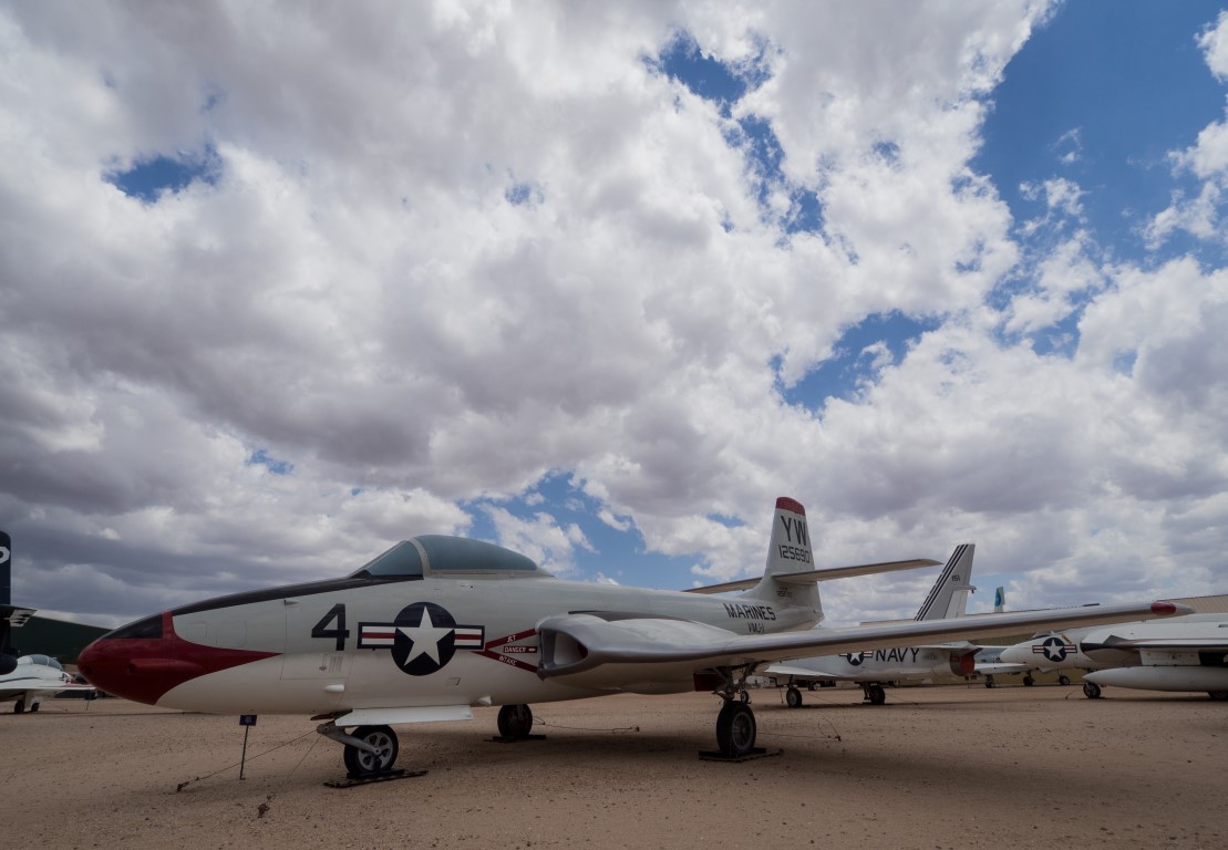
We also managed a day-long excursion to the Pima Air Museum, another world-class facility in (no offense to South Tucson) an unlikely location. The air museum is the third largest in the U.S. (behind the National Air & Space Museum and the Air Force Museum at Wright-Patterson) and not only has its own excellent collection of vintage aircraft, it also houses a separate museum for the 390th Bomb Group (complete with an intact B-17) and coordinates with the Davis-Monthan AFB “boneyard,” where aircraft are sealed up and stored pending either reactivation or dismantling.
The Pima Air and Space Museum has over 150 vintage aircraft displayed on 80 acres (!), including this F2H “Banshee,” a plane that has special significance to me because my dad was one of the test pilots for the development of this early jet-age fighter. The outdoor display is so large that one actually takes a guided tram tour to see it all.Dozens of F-16s sealed up and put in dry storage at the Davis-Monthan AFB “boneyard.” There are over 1000 aircraft stored here in the perfectly dry climate where they can basically be parked indefinitely, although those aircraft identified for potential reactivation have periodic inspections and maintenance, including running up the engines at least once per yearThe F-117 Stealth Fighter. The Air Force used to provide special glasses that would allow visitors to see the collection of stealth aircraft, but the base was on high security and so we were not provided those glasses. Still, it was quite a treat to be this close to so formidable a weapon.
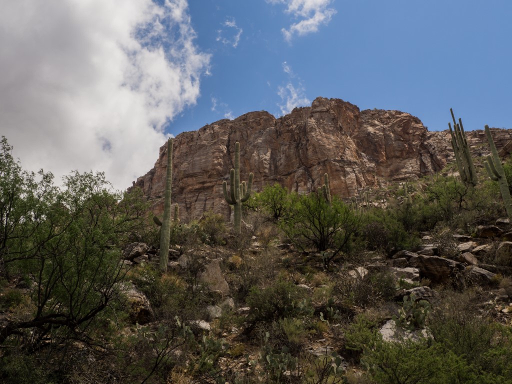
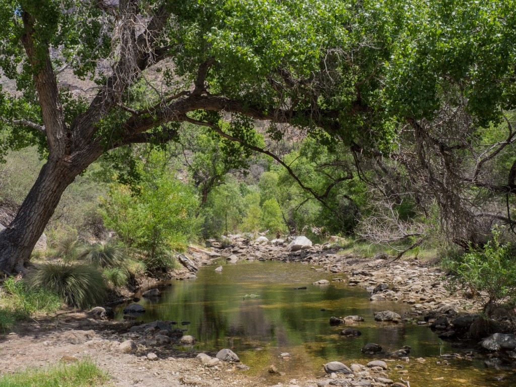
And, Susan took us to another unlikely, but completely wonderful, spot, Sabino Canyon. This is something unlike anything Wendy and I have seen before. Sabino Canyon is a deep canyon in the desert outside of Tucson that contains a perennial stream. What made it unique is that the U.S. Forest Service operates a tram that takes visitors up the 3.8-mile canyon on a guided tour, pointing out the geological and biological features of this unlikely stream in the middle of the desert. Then, visitors have the option of taking the tram back down or, as we did, enjoying a leisurely two-hour hike back to the visitors center.
The steep, sheer walls of the Sabino Canyon, fully adorned with Saguaro cacti, which often look to me like people with their arms raised.Amazing. A perennial stream in the middle of the desert. Even in the heat of the summer, pools remain that sustain fish life! And walking along this and marveling at such an improbable feature is made possible by a tram service (!) sponsored by the Forest Service.
The highlight of the week, by far, though, was a trip to the Arizona-Sonora Desert Museum. The “museum” is a combination of a botanical garden, wild animal park, zoo, and educational facility, all wrapped up in an authentic desert layout. One strolls about over several miles of trails and walkways, seeing the flora and fauna of the Sonora Desert as one might see it over years of backcountry hiking. Seriously. This is the second time we thought we were attending some little second-rate “local” museum (the first was our trip to Cody, Wyoming) only to be met a world-class facility that is as good as one can find anywhere.
In addition to a wonderful indoor exhibit of reptiles, insects, and an amazing assortment of little desert creatures that will sting, bite, or otherwise poison you, there’s wide array of animals native to the Sonora Desert were on display in man-made but natural-looking habitations:
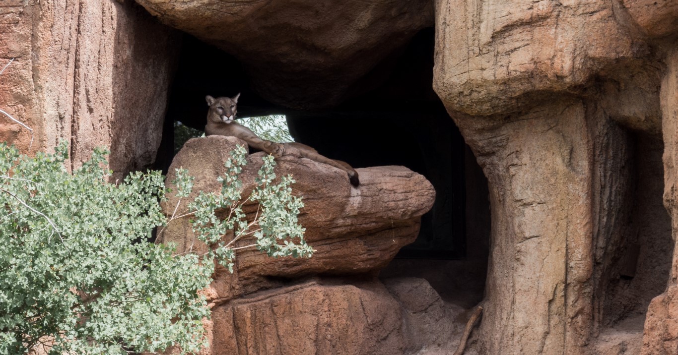
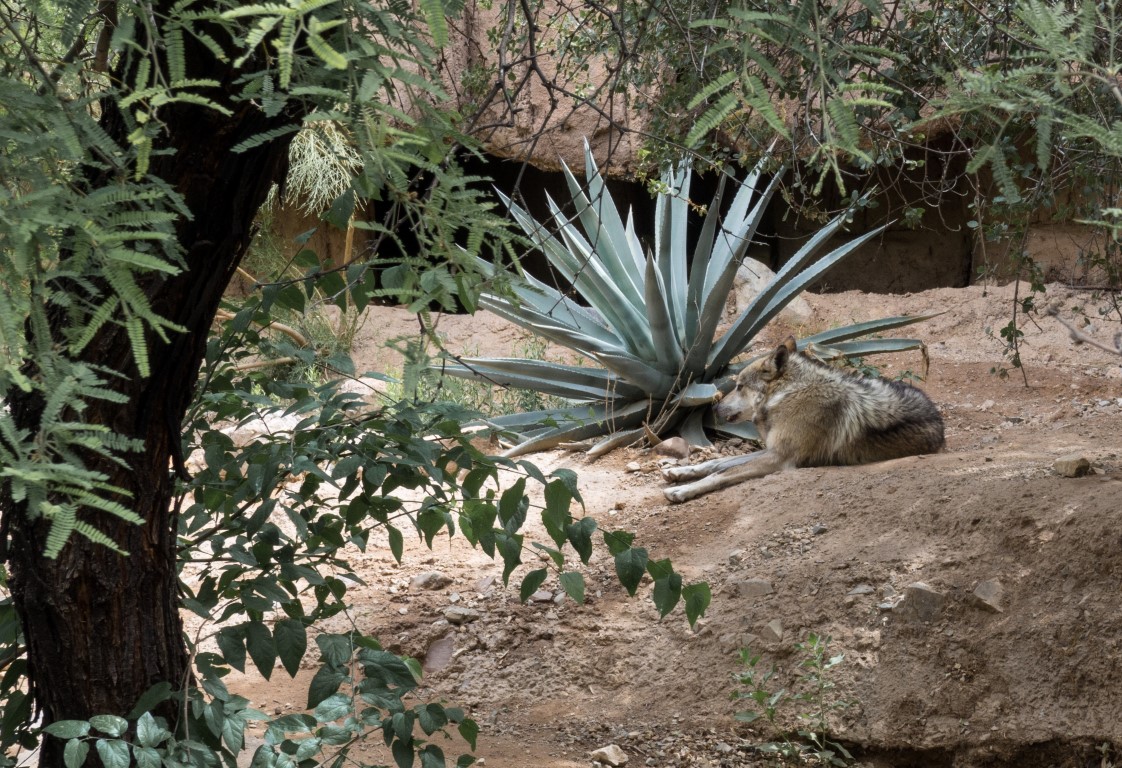
Mountain lion. We asked the docent if it’s true that mountain lions actually stalk humans. The answer sounded a lot like a contrivance the gist of which is that “stalking” is not actually what they’re doing, but it seemed to me that the answer was basically yes.A nice-sized wolf, assuming any size of a wolf can be “nice.”Mommy and daddy big-horn sheep. Not visible here are two lambs, the older of which seemed intent on pushing the younger one over a cliff, which either illustrates the sometimes harsh nature of natural selection or explains a lot about young boys of all species.
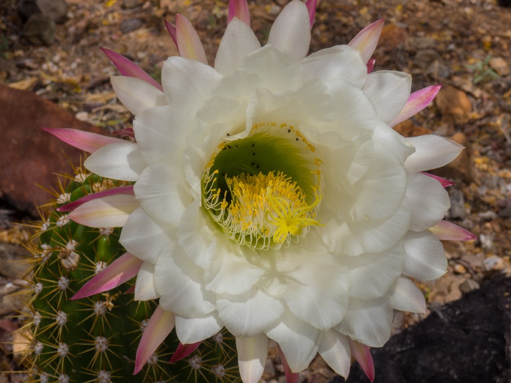
And there was an extensive cactus garden, with many of the species in full springtime bloom. [Click on the thumbnail photos to enlarge]
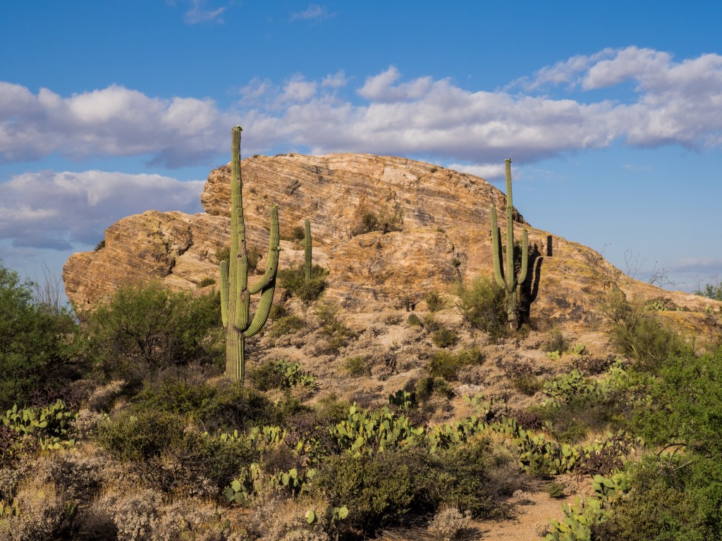
We did make a quick stop to Saguaro National Park, but given how excellent were both the Sonora Desert Museum and the Sabino Canyon excursion, the national park was actually something of a let-down. Think about that. How often can a national park be a let-down?
There are two units to Saguaro National Park. This is on the east side, supposedly the less enjoyable of the two, although it may be more photogenic.
So that ended our “layover” in Tucson. Six days of non-stop eating and touring, excellent in every respect, all made possible by Wendy’s wonderful sister.
Next stop: Mesa Verde National Park and southwest Colorado.
After arriving in Alamogordo and setting up at the campground, we went out and looked at sand. Lots of sand. Some of it was in piles. That’s it. Good bye.
Actually, contrary to what one might think, going to White Sands National Monument is not just about going to look at big piles of sand. First of all, it’s not “sand” as most people would think of it. Such sand is ground up rocks (mostly quartz). The White Sands stuff is granules of gypsum, like in wall board and plaster of paris and toothpaste, that started as big gypsum crystals created when gypsum washed out from the surrounding mountains and just recently (over the past 7000 to 10,000 years, which is a blink of an eye in geological time) got eroded into small particles by the action of the constant desert winds. So, there are heaps and heaps, over miles and miles, of gypsum granules forming an unbelievably picturesque landscape. In fact, there are 275 square miles of these dunes, the largest in the world. But the geological story doesn’t end there. Gypsum is (1) water soluble and (2) easily blown away, so on both counts it shouldn’t even be here. But, since I saw it, I’m pretty sure it is. How can that be? I don’t fully understand the geology (even after attending a ranger talk on the topic), but it turns out that there’s a perched aquifer just under the surface of the dunes that binds up the base of the gypsum fields so that, while the top few feet of the dunes get blown hither and yon by the wind, the mass of the gypsum remains fixed within the confines of this subterranean water, and then with each rain, gets formed into big crystals, eroded into sand, and the process repeats.
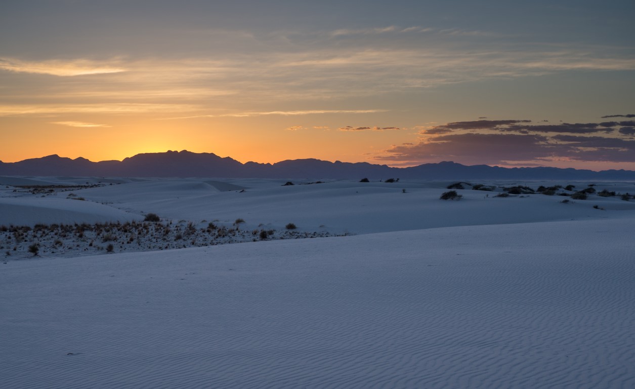
Miles and miles of stunningly white gypsum (sand), created in an improbable geological process starting with gypsum being washed out of the San Andreas mountains in the background
The other thing that makes White Sands NM unique is that unlike most venues under the jurisdiction of the National Park Service, where a “look but don’t touch” rule is enforced, at White Sands the NPS wants everyone to go out and play in the dunes! Really. Not just hiking and picnicking and nature trails and ranger talks and all the usual stuff, all of which abound and are very well done, people are encouraged to drive along an unpaved road of hardened gypsum, climb the dunes, and walk out into the area and take in the breathtaking beauty of the white expanse of rolling dunes. NPS even sells flying saucer sleds in the visitor center! It’s almost as if NPS were saying, “Look, anything you do is going to get obliterated by the wind in a day or two anyway, so go out and have a blast!” And people do. We went on a short hike into the dunes, and part of the fun was trying to scramble up the dunes with your feet slipping backwards almost as fast as you can move forwards. It’s like playing in the snow, but in a way that’s warm and dry. If you used to be a kid, coming to White Sands is a ton of fun.
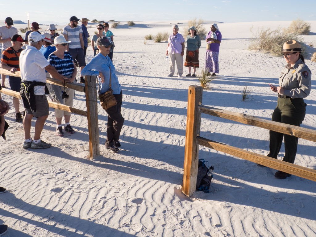
Getting ready for an early evening ranger-guided stroll into the dunes. Of course, because this is an NPS function, the experience was perfect and our guide was knowledgeable, engaging, and funny. We’ve noted it before, but the ranger cadre of NPS is definitely one of its greatest assets.The ranger-guided walk ended at sunset and we were treated to one of those flaming orange desert sunsets. The sliver of plant-laden dune in the center-left of the picture is the “inter-dune area,” where the aquifer lies just about 20 inches or so beneath the surface and holds the whole dune field together.
White Sands is one of the stops made by the family back in 1988, one that they always raved about. I never understood why until now. What a great place.
Normally, I’m not big on caves, which have always impressed me as nothing more than big, rocky holes in the ground, and even if they have the usual assortment of formations, all properly lit up, the experience wears off in a few moments and I’m back to being trapped in a big hole. So, the main attraction in heading to Carlsbad Caverns was less the caverns than seeing the bats, which emerge from the cavern every night at dusk, and which I’ve heard about from Wendy and the family ever since they visited there in 1988.
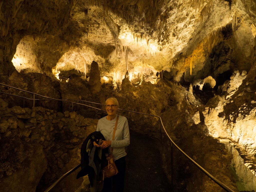
First, I was wrong about the caverns. Like, embarrassingly wrong. (No wonder no one ever listens to me.) Carlsbad Caverns is definitely not just a big hole in the ground. Actually, it is a big hole in the ground, but it’s so big, and so complex, and so stunning in its visual impression that it nearly defies description. We did one of the self-guided tours (we got there too late for a guided tour), which took us into the caverns for a loop of about 2-1/2 miles, starting with an 800-foot descent on a switch-backed trail through the main entrance, and eventually into the “Big Room.”
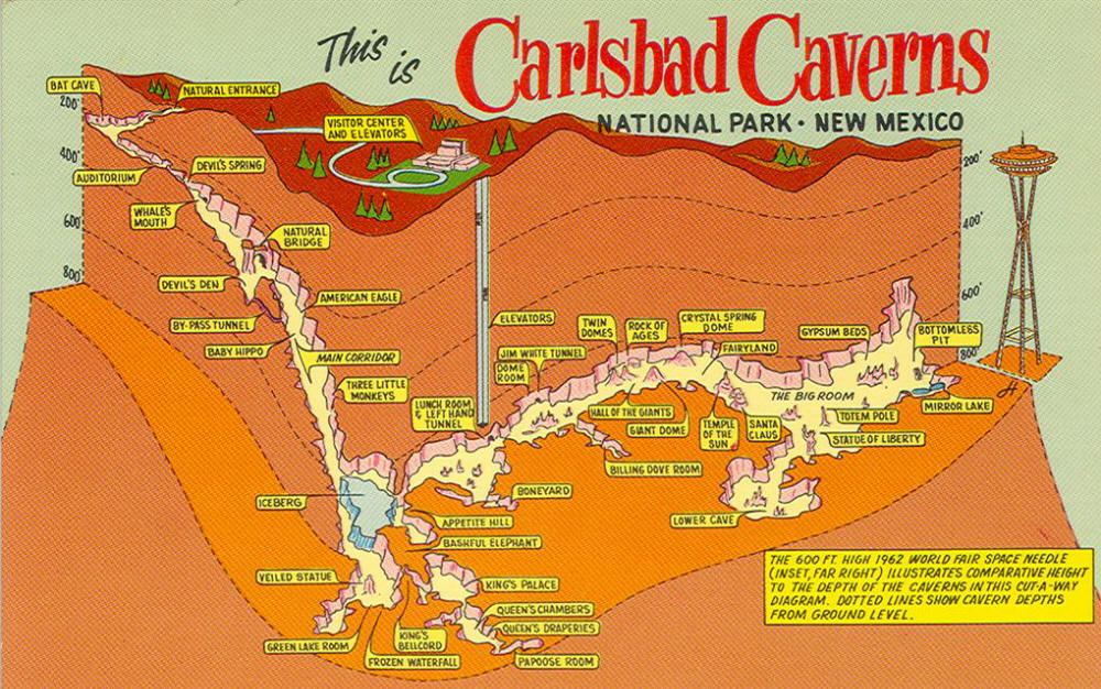
This is some dippy retro post card that I found on the internet, but it’s the best depiction I found of the layout of the caverns. The self-guided tour, about 2-1/2-miles long, enters down the “natural entrance” on the upper left, all the way over to the “Big Room” on the far right, and then back to the elevator for the 750-foot lift back to the surface.
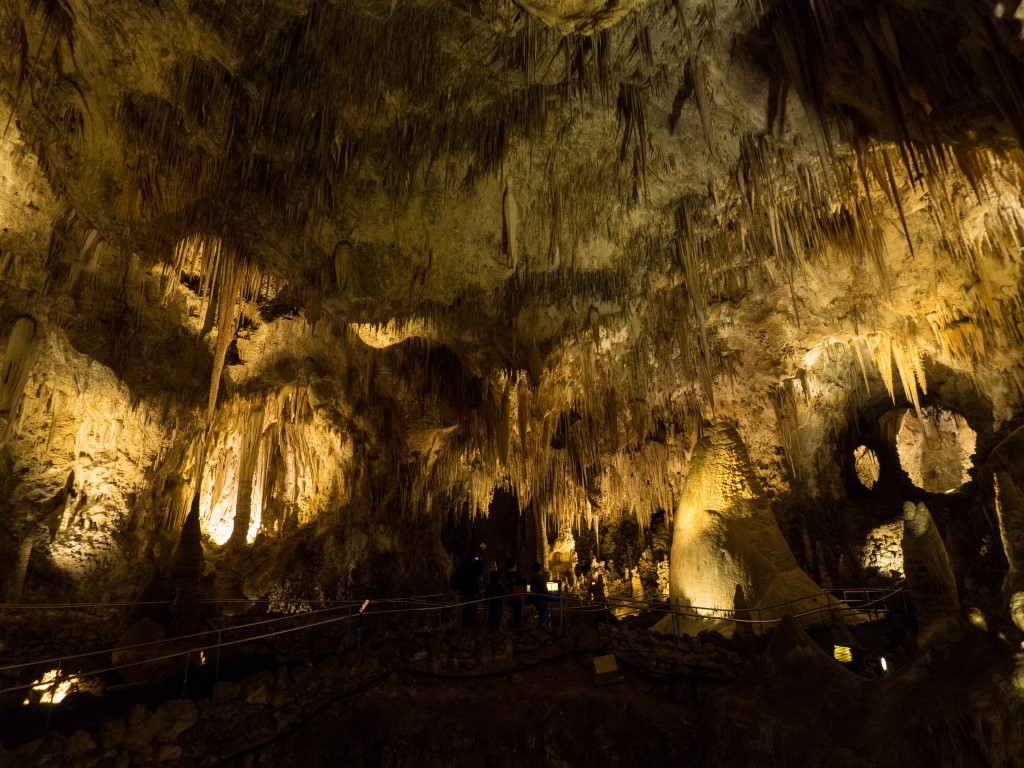
The “Big Room,” for example, although it’s just a teeny part of the caverns and just one part of the self-guided tour, is huge: big enough to put the U.S. Capitol building in there twice! At one point, it’s 250 feet tall. One side loop around the Big Room is a mile long! This part of the cavern system is only one of about 100 such caverns, most of which have never been explored. In 1986, some guys accidentally discovered a side-branch to the cavern system, and so far they’ve explored it for 150 miles. As the short film in the visitor center pointed out, it’s hard to find any place on the surface of the earth that isn’t fully explored, but beneath our feet, literally, we haven’t even begun to explore our own world.
And somehow the National Park service has managed to install paths, and handrails, and lighting throughout this portion of the caverns.
You’d actually do better to look up images of the caverns on the internet than settle for my amateur attempts to capture the scenes with my camera, but this image makes the point. Note the path winding through this portion of the Big Room. And, although this image doesn’t exactly capture the lighting, the National Park Service hired a theatrical lighting expert to do the lighting with the objective that the interior of the caverns would be illuminated, but the effect would still be “cave-like.” They succeeded on both counts.I forget how deep we are into the caverns at this point, but we were approaching the time when they closed up the caverns for the day, and we were deep enough that we decided to get one last picture of us alive in case things turned out otherwise.
The bottom line is that I could easily go back to the caverns again and spend more time just marveling in its complexity and beauty.
Second, I was right about seeing the bats, but first a brief digression.
[Social Commentary /on] There is an amphitheater near the entrance to the cave where visitors can sit down at dusk and watch the flight of bats as they emerge. Everywhere one looks, there are signs explaining that all electronic devices must be turned off (not just put on silent or in sleep mode). No active cameras, cell phones, or other electronic devices are permitted because they interfere with the bats’ behavior and ability to navigate. So, for the good of the bats, and for the benefit of the experience, no exceptions. Everything must be off. The effect of those signs? Zippo. Nada. A huge percentage of the visitors, Wendy and I estimate about half, were completely loaded up with cameras (some even set up on tripods!), cell phones, selfie-sticks, and God-knows-what, all ready to blast away as soon as the bats emerged. What? What’s going on here? The only thing Wendy and I could figure out is that about half of the population, here at least, but probably everywhere, doesn’t care about nature, doesn’t care about their fellow man, and doesn’t particularly care even about the quality of their own experience. As long as they can take some inferior little snapshot, and take it home to their equally self-focused and despicable friends and family, they’re willing to ruin the very thing they came to see. How sad. Fortunately, though, an armed park ranger showed up just before dusk and said that his job was to protect the bats, that using electronic devices was a citable offense, and that if the devices weren’t turned off and put away at this point, those using them were subject to arrest. That did it. Apparently, the problem is widespread enough that the National Park Service has learned that, if moral force isn’t enough, the prospect of making little ones out of big ones in a federal pen will ensure compliance. [Social commentary /off]
And the bat experience? Apparently we were there too early in the season and most of the colony of Mexican Free-Tailed Bats won’t return from Mexico for another month or two. So, right now, there are “only” 20,000 to 30,000 bats in attendance! Precisely at dusk, though, as if on cue, hundreds of bats emerged and begin circling in front of the cavern entrance, racing around at incredible speeds, somehow managing not to collide, gaining altitude with each loop, until they reach a height sufficient to head off into the countryside, and away they flew. Then another flight emerged, again spiraling upward, faster and faster, higher and higher, and then heading off. And then another flight, and another, and another. It seemed like it would not end. I later asked the ranger if the bats were actually emerging in groups so they could form up into “squadrons,” so to speak, but that’s not what they’re doing. They are actually solitary hunters. But they have to spiral upwards because their little wings don’t generate much lift. In fact, most of them can’t even take off from the ground. They are, as he put it, “the jet fighters” of the bat world. After 45 minutes or so, now in almost total darkness, the bats were gone and we headed back to the campground. Had we been here in June or July, it would not have been a few tens of thousands of bats, it would have been hundreds of thousands. I can’t even imagine what that would look like.
So, add this to the list of reasons we’d return to Carlsbad Caverns for an even better re-do of the experience.