We’ve been to both Arches and Canyonlands National Parks back in May of 2017, and the question is whether a repeat visit would feel more like a “been there-done that” experience, or just as good as the original. It was definitely the latter.
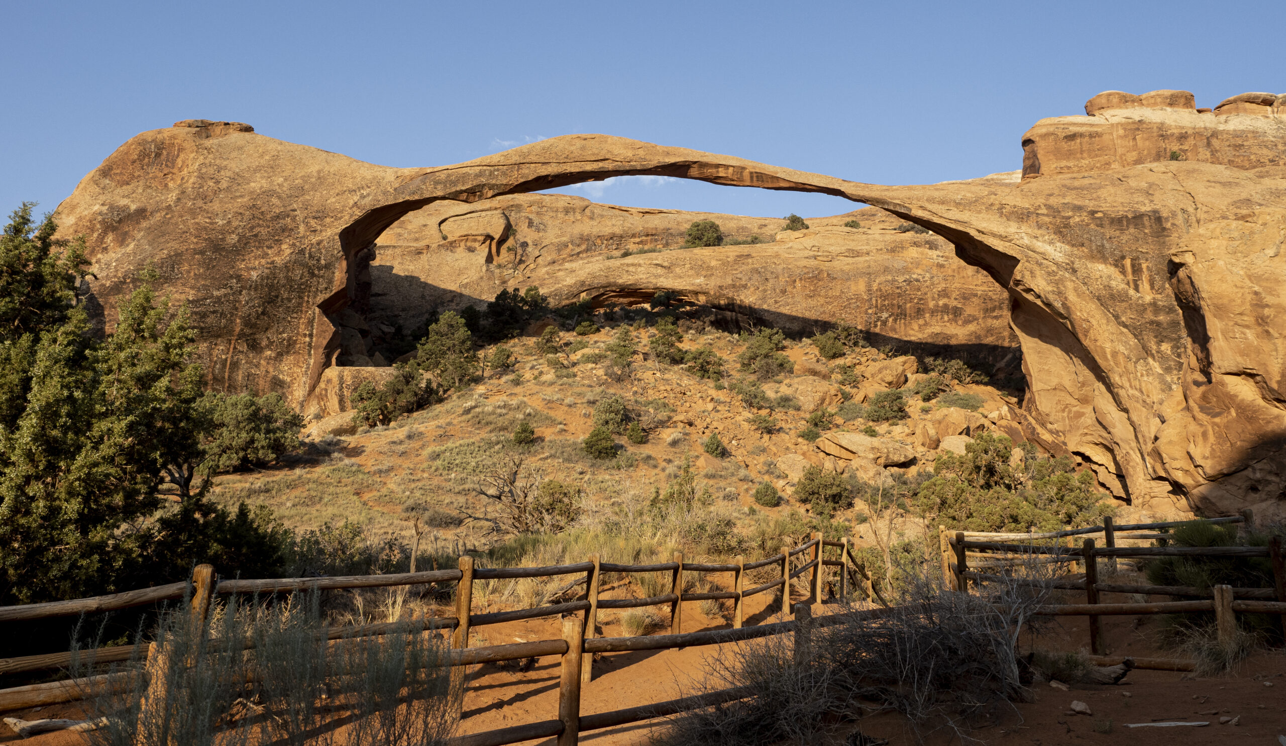
There are two reasons why this visit lost nothing of the appeal of our first. First, there’s so much to do at these parks (at most any national park for that matter) that each visit can can provide a wealth of new experiences. For our visit to Arches, for example, we missed the hike to Landscape Arch back in 2017. So off we go and that experience alone was enough to make the visit worthwhile.
At a 306-foot span, Landscape Arch is the largest natural arch in the United States, and the fifth largest in the world (after four in China, which are probably fake).
One has to wonder, “How does that dang thing stay up?” As it turns out, that’s exactly the same thing the Park Service wonders, which is why they’ve closed off access and don’t allow anyone near it. That sucker is definitely coming down soon, and not “soon” in “geological time,” “soon” like maybe next Thursday (one large slab fell off in 1991 and two more fell off in 1995).
The second reason visits to these parks never grows old is that even for the sights and scenes we’d done the first time, they’re somehow new and different when done again.
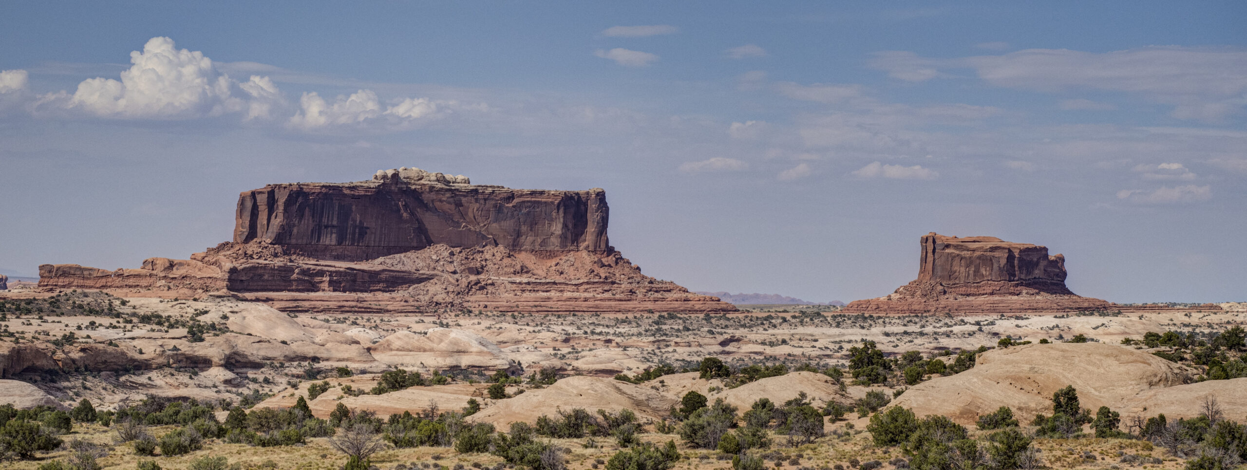
Two buttes on the road to Canyonlands, named the Monitor (right) and Merrimac (left) Buttes.
We’d no doubt driven by these buttes dozens of times, but this trip the scene just struck us and we pulled over, enjoying the sight as if it were the first time.
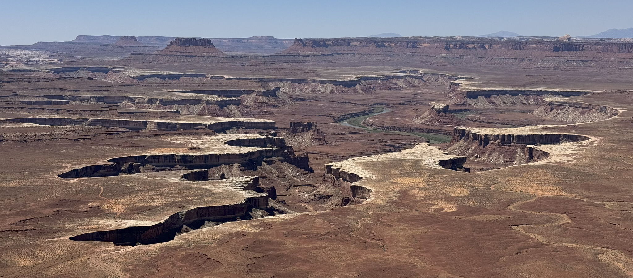
Same whole-new-experience with a hike out to Grand View Point Overlook:
Just on the other side of that butte is where the Green River and the Colorado River come together.
And even ditto with the Shafer Trail Overlook:
Yes, that is some idiot in an F-150 driving down the Shafer Trail to the White Rim Road. (And no, it’s not me … it’s a different idiot.)
Ditto with the Green River overlook:
This picture is almost identical to one I took seven years ago, but somehow this one felt “new.”
Wendy and I talked about how it could be that something we’ve seen before can be “new” and “different” when we see it again. What? One obvious possibility is that our aging brains have forgotten what we’ve done and so as far our our neurons can make out, this really is brand new. The more likely alternative, though, is that there’s a difference between a memory of a place and a current encounter with the same place, and no matter how vivid the memory, it can never compare to a present experience. Recalling an experience can never be the same as having the experience, and for that reason our trips to Arches and Canyonlands were indeed brand new. Who knows? Maybe we’ll be back in a few years for a new experience again.
Having arrived in Moab, we followed our usual course and went to the visitor center at Arches National Park, asking the ranger for his suggestions on the best ways to spend our 3-1/2 days here. After discussing a few of the options, he said, “If you can spare a day, you really ought to visit The Needles District of Canyonlands. It’s worth it.” That possibility was on our list anyway, so on Friday, July 26, off we went.
To get to The Needles, one has to drive 40 miles south of Moab, and then 35 miles west on State Route 211. Far from being just a long drive, however, State Route 211 presents its own, fascinating story.
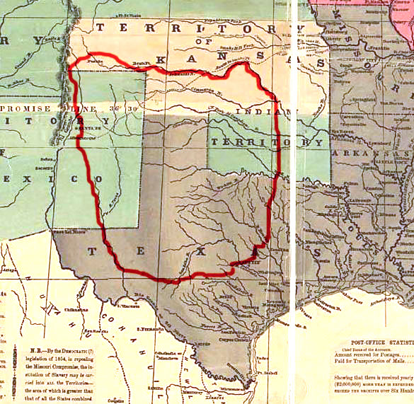
Route 211 passes through the what is now the Bear Ears National Monument. National monuments, because they are created by Presidential fiat, are often controversial, but this one is a doozy.
After decades of maneuvering by Native American groups and self-appointed conservationists, on December 28, 2016, even though it was after Donald Trump had won the 2016 election and Obama had only days left in his term, President Obama designated 1,351,849 acres of land in Utah as the “Bear Ears National Monument,” making it the third largest national monument in the continental United States. (For what it’s worth, the largest national monument is also in Utah: the Grand Staircase / Escalante National Monument at a whopping 1,870,000 acres. One way or another, the federal government owns 63.1% of the state of Utah. Things could be worse, though; it’s 80.1% in Nevada.)
In any event, almost immediately after Obama made the designation, opponents (including Utah’s governor and legislature) started working on ways to undo Obama’s parting decree. President Trump got the message and promptly commissioned an evaluation of the designation and then, barely one year later, reduced the size of the monument by 85% to 201,000 acres.
When Joe Biden won the 2020 election, the original proponents starting working on ways to undo Trump’s undoing of the original designation, so in October 2021, President Biden restored the designation to its original boundaries.
If Donald Trump wins the 2024 election, one can confidently look forward to the undoing of the redoing of the undoing of the doing. And for those of you who wonder what kind of land use policy is reflected in this back and forth, all I can say is, “welcome to America.”
Back to the trip …
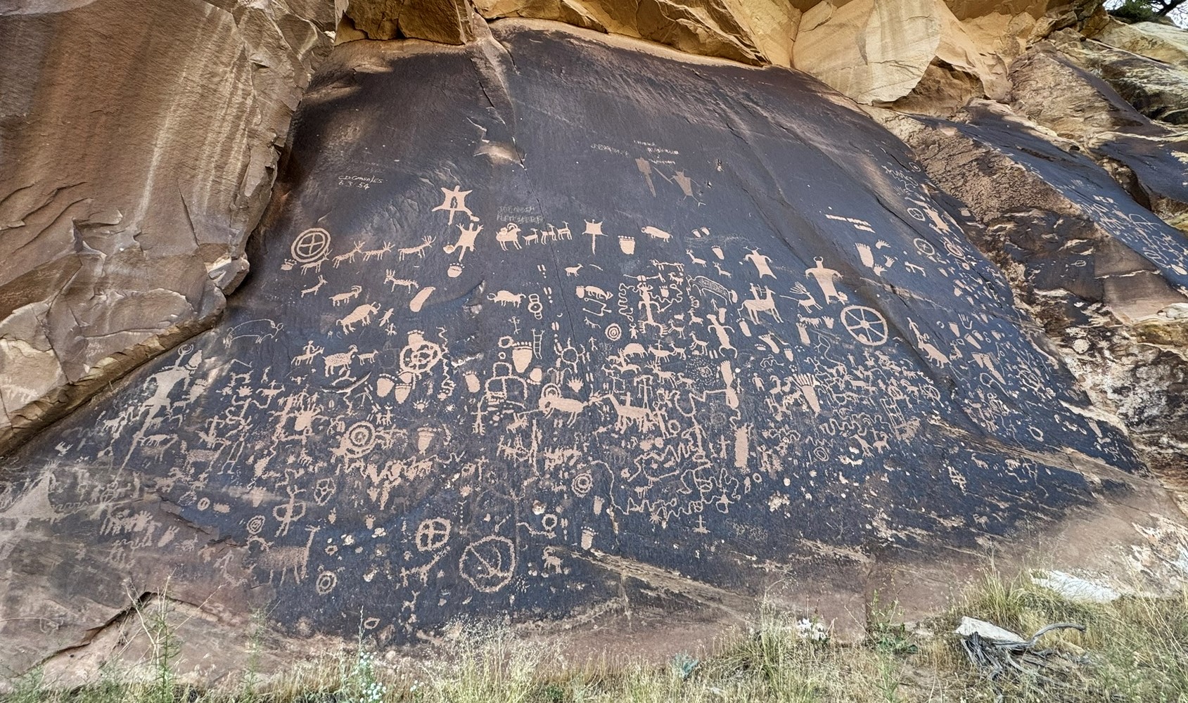
The first thing one encounters on the path to The Needles is “Newspaper Rock.” Indeed, we were told that Newspaper Rock is a must-see en route to The Needles.
I understand that these kinds of petroglyphs are very important to native cultures whose ancestors did the work, but other than as a sort of family notebook, it’s hard to see the broader significance of such primitive doodles.
Newspaper Rock didn’t do much for us. I asked the ranger why such things are considered important and he said that the carvings were 2000 years old and told passers-by where to find game, water, encampments, and so on. Meh. Compared to other cultural compilations of knowledge from 2000 years ago (like the Library of Alexandria, for example) a few stick people doesn’t seem like that big of a deal, but I guess if it’s your grandma, it’s a different story.
Where Bear Ears National Monument does start to get interesting, though, is in the geological formations that line the roadway.
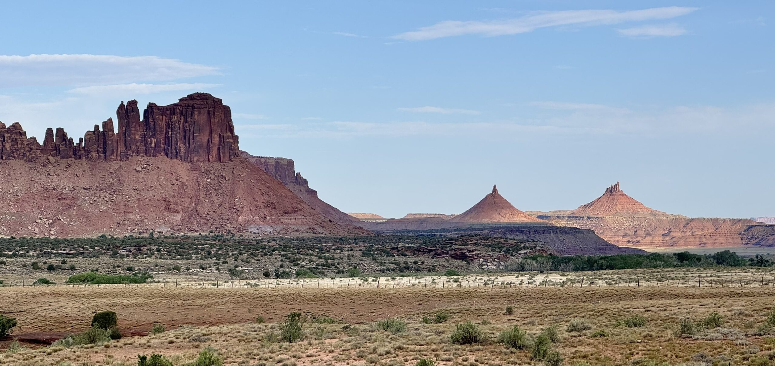
Bridger Jack Butte and the Six-Shooter Peaks. Very reminiscent of Monument Valley.
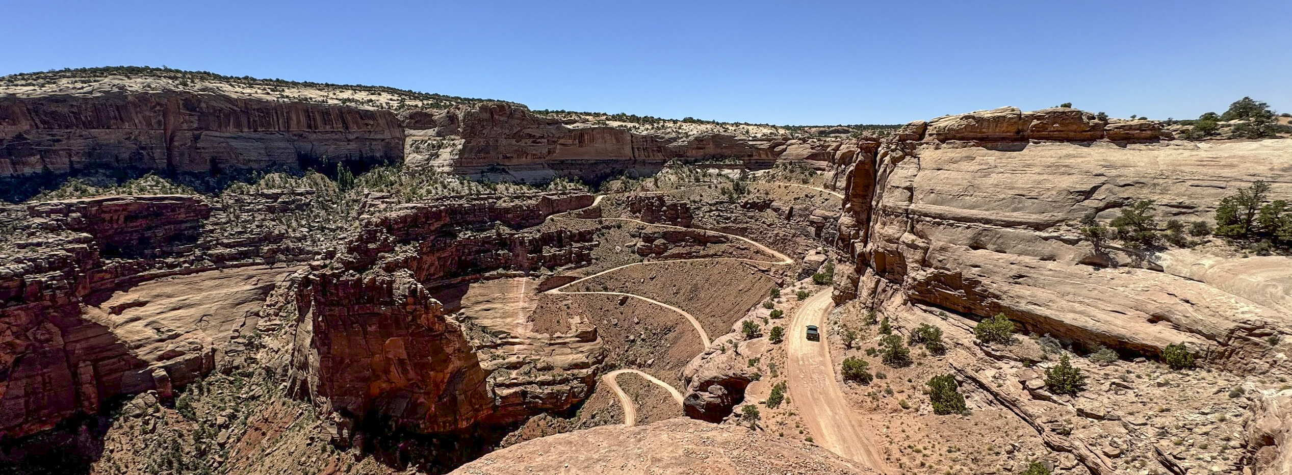
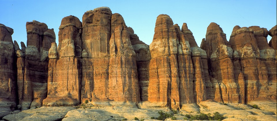
And after the drive through Bear Ears, the real treat was The Needles, an array of sandstone spires that were formed when a giant salt dome pushed up the crust of the earth, split it into a series of parallel cracks, and then erosion erased everything down from the cracks.
It’s hard to capture in a photograph, but these spires pretty much go from horizon to horizon.
We did a few hikes (Cave Spring and Pothole Point) and drove down to the Big Spring Canyon overlook. I toyed with the idea of driving to the Colorado River overlook, a 7-mile dirt road that leaves from the Visitor Center, with long stretches of soft sand, and is described as “technical.” Well, I’m a pretty technical guy, and I have a 4-wheel drive truck (admittedly with street tires), so I asked the ranger if he thought I could negotiate the route. “Are you very experienced?” he asked. “No.” “Don’t.” So much for that idea.
As usual, the advice from ranger we got when we first arrived was exactly right. With a day to spare, The Needles is a must-do destination.
As noted, traveling to parks “out west” means a lot of traveling. Like, thousands of miles. To get to the first stop worthy of a stop (Durango, Colorado) is 1600 miles of cross-country endurance, which translates to 6 days at our relaxed pace. So, to pass the time, we will often listen to books on tape. A few years ago, we listed to Undaunted Courage as, not coincidentally, we meandered northwest along the Lewis and Clark route. In a similar way, this trip found us listening to Empire of the Summer Moon, a story that culminates at the Palo Duro canyon near Amarillo, an intermediate stop on our route west.
Hold that thought …
When we were young, depictions of American Indians typically took one of two courses: they were either noble natives, who lived at one with the land, peaceably communing with nature while they did joyful dances beating their tom-toms; or they were vicious savages who rode out of the sunset, screaming like the crazed killers they were, and scalping every white man they met, except for those they tied to ant hills to bake in the sun. Never mind that neither depiction was very accurate, or even that trying to generalize the traits of “Indians” as a class makes as much sense as trying to describe the character of Prussians, French, Italians, and Brits as one class of “Europeans.”
Even still, I could never totally jettison the image of vicious red men lurking behind every rock in the Western landscape. I sometimes felt a little bad about harboring such an unfair stereotype, but that guilt was considerably lessened as we listened to Empire of the Summer Moon. It turns out that the Comanches lived up to every bit of that stereotype, and more. They lived in a culture that lived for war, first by attacking the neighboring tribes they encountered, and then by turning their finely honed skills on white men as settlers encroached on the Comanches’ territory. Using their unparalleled skills as horsemen, they would descend on a settlement, killing and scalping the men, raping and mutilating the women, and taking the children as slaves.
The Comanches were so fearsome in battle that for over 150 years, they essentially dominated most of the Southwest in an area that came to be known as “Comancheria.”
Here’s where Empire of the Summer Moon comes in. In 1836, Comanches descended on Fort Parker and, after doing what Comanches do, took a number of the children as slaves, including a nine-year-old girl, one Cynthia Ann Parker. Over time, Cynthia Ann assimilated into the tribe, and eventually married the chief Peta Nocona. In around 1850, Nocona and Cynthia Ann had their first child, Quanah. While all of this was going on, the Parker family was desperately searching for the kidnapped children. That story is what is loosely described in the John Ford film, The Searchers, starring John Wayne. In any event, Quanah grew to become a fearless warrior, and, in the Comanche manner, his prowess in battle caused him to be selected as the chief of the band.
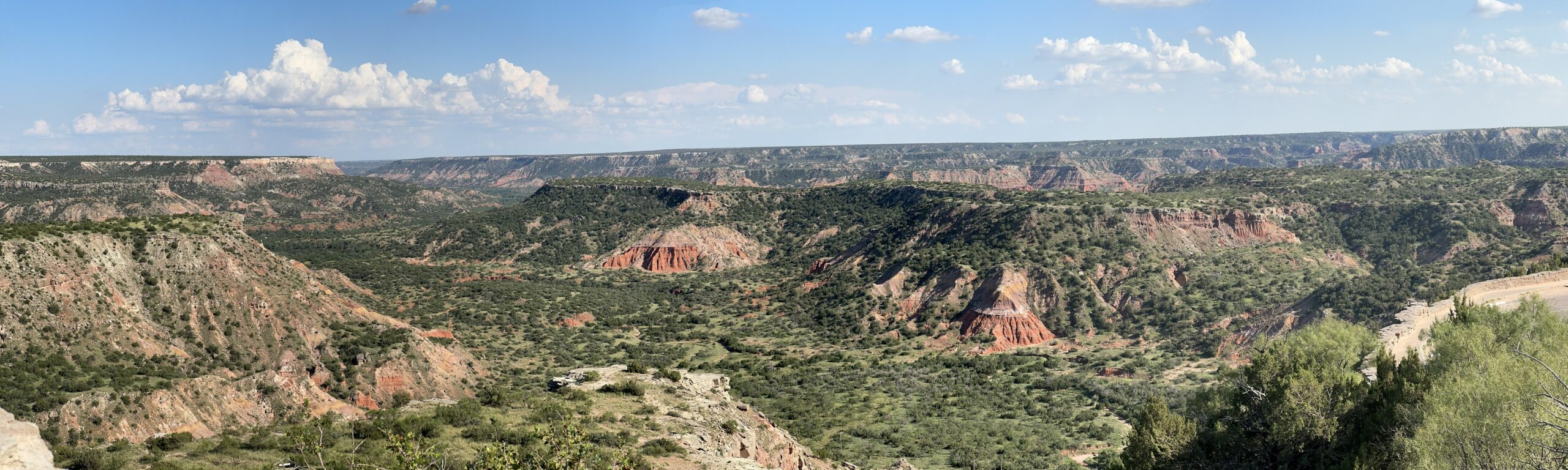
Fearsome warriors or not, the growing white presence, and pressure from the U.S. Army, was taking its toll on the Comanches. In 1874, a number of Comanche Indians, along with members of the Cheyenne, Arapaho, and Kiowa tribes, had taken shelter the Palo Duro Canyon.
The Palo Duro Canyon, just south of Amarillo, is the second largest in the United States, roughly 40 miles long and from 1 to 20 miles wide. In the 1870s, it was right in the heart of Comancheria.
The 4th U.S. Calvary, under the command of Colonel Ranald S. Mackenzie, moved against the encamped Indians. Although under intense fire from Indians in the slopes above the valley, Mackenzie’s troops effected a complete rout of the tribes. Indian casualties were light, but they lost all of their winter stores, and their encampments were burned, and, even worse, 1000 to 2000 of their horses were shot. The effect of the “Battle of Palo Duro Canyon” was that the Comanche wars were over. With no food, no shelter, and no means of movement, Quanah Parker realized all was lost and persuaded the Comanches that further fighting was futile. In 1875, Quanah and his band of Comanches surrendered at Ft. Sill.
Wendy and I spent the day touring around Palo Duro Canyon State Park, and even attended a wonderful little musical in the park amphitheater that recounted the history of the region. Interestingly, the guy who portrayed Quanah Parker in the musical was actually one of his direct descendants. In our view, our stop in Palo Duro Canyon, even though just a waypoint on the journey to our “real” stops out west, was time well spent, and listening to Empire of the Summer Moon and then visiting the place where the grand story reaches its final conclusion, made this part of the trip especially worthwhile.
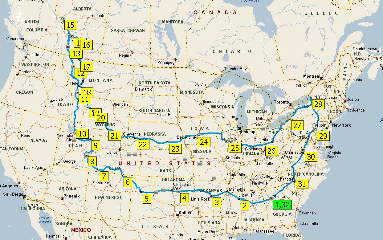
There’s no doubt that all of our favorite parks are out west. The problem with parks “out west” is that they’re all out west. Like way out west. The closest of the “out west” parks might be those around southwest Colorado and that’s 1500 miles away (which is 5 RV-days). So, we don’t do our favorite parks as often as we’d like. Last time we did a loop around the out-west territories was 2000.
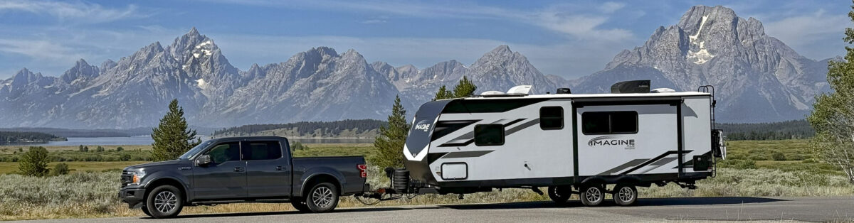
But it’s 2024 and we’re doing another such excursion. But this one is even bigger, better, and bolder than past trips. Not only does it include all of our favorite out-west parks (the Utah parks, Glacier, Grand Teton, and Yellowstone), we’re throwing in two of the best parks in the known universe: Banff and Jasper national parks in Alberta, Canada. And then, since we’ll be “in the area” (in our family’s sense of the term that upstate New York is “in the area” of Atlanta), we’ll swing by Fort Drum to visit son #3 and his family, stopping by the Air Force museum in Wright-Patterson AFB since it’s sort of “on the way.” Totals for the trip: 2 months, 7500 miles, 11 favorite parks, and a bonus family stop.
We’re scheduled to leave mid-July and be back mid-September. Updates along the way will follow …