The caption is right on all counts, starting with the fact that I’m writing this while sitting in the RV in the Peculiar Park Place RV Park, located in Peculiar, Missouri. Seriously. There are a variety of explanations as to how this town came to earn its moniker, but the leading candidate is that the guy who surveyed the town wanted a unique name and kept submitting various unusual names to the state, all of which were rejected, until in exasperation he said, “I don’t care what name you give me, as long as it’s peculiar.” He asked for it…
The reason we’re here in Peculiar, though, is that we finally got into the RV for an actual trip. It took us FIVE tries. First was a trip to North Carolina with all four families. That didn’t work because Robert got eliminated by the flying fickle finger of fate (AKA DoD), which imposed a 250-mile travel limitation. Version 2 was three families in the same location, which got nixed when we decided, correctly, that two families in one RV during an epidemic was a tad too risky. Version 3 was a two-family trip to some random state park in Virginia, which got cancelled because, well, who wants to go to some random state park in Virginia? Version 4 was the same two-person group, but headed to Grand Teton National Park. That got cancelled because Cliff realized that the prospect of flying cross-country with three children, connecting in O’Hare, dodging infected people, dousing the upholstery with antiseptic sprays, while everyone was wearing masks, including a four-year-old, was nuts.
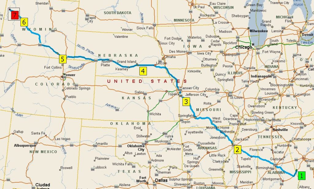
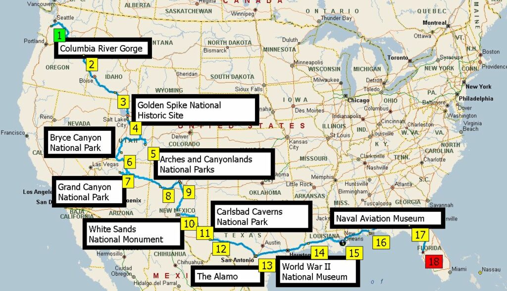
So, here we are with version 5: Wendy and I travel cross-country over 4-1/2 days and we do Grand Teton National Park on our own.
1892 miles, over 4-1/2 days, from LaGrange to Colter Bay, Grand Teton National Park.
RV travel during a pandemic presents a unique combination of considerations. On the upside, RV travel means no hotels, no restaurants, and no public bathrooms; we can, in essence, self-isolate while we travel around and see the country. That explains why most RV dealers have found their inventory depleted and the RV rental companies are booked for months in advance. The downside of RV travel during a pandemic is that it occurs, well, during a pandemic. That, in turn, means that places and activities where people naturally congregate are closed, such as the Grand Teton’s ranger stations, visitor centers, ranger talks, and ranger-led hikes. That’s a significant issue for us — we enjoy all of those activities. We always start out a visit to a national park by reviewing all the information and displays at the visitor center, no matter how many times we’ve been there, and we pretty much go to the ranger talks every night. Still, it’s Grand Teton National Park, the singularly most beautiful place on earth, and we look forward to a great time, add-ons or not.
We’re sitting here, properly sheltered-in-place, wondering what will happen to our planned RV trips this summer. Right now, we have two trips on the calendar: one in June-July with Robert and family, starting here in Georgia, then up to Great Smoky Mountains National Park, then over to Charleston and the Yorktown, then down to Cape Canaveral and the Space Center. The second trip in July-August is out to Grand Tetons National Park with Cliff and family, then into Montana for a week, then home. Will the COVID-19 epidemic quash those plans? What is the best guess at this time? To answer that question, one must understand government stupidity.
First, a digression. Recall the 9-11 terrorist attacks. In response, the government announced there was a public welfare emergency, therefore it was increasing its control of American society and imposing a wide array of emergency restrictions. One of those restrictions, notably, was a prohibition on anyone boarding an airplane with nail clippers. Seriously? Nail clippers? Did the government actually think that nail clippers could be used to seize control of a commercial airplane? There’s a story, maybe apocryphal but informative anyway, that the ban on nail clippers was even applied to a pilot, who responded, “Look. So far as I know, there’s no way to seize control of an airplane with nail clippers. But even if there is, it doesn’t matter. I don’t have to seize control of the airplane. I have control of the airplane. I’m the pilot.” No avail. Bye-bye nail clippers.
So, call this kind of government lunacy the “nail clipper effect.”
Now, here we are in the midst of the COVID-19 shutdown. Once again, the government has declared a public welfare emergency and clamped down with all sorts of exceedingly heavy-handed restrictions, all (supposedly) for our own good. Some of them (most, probably) are in fact sensible and necessary. This is an important public health crisis and the government is properly taking dramatic steps to deal with it. And in any event, I’ve always hated people who claim a prerogative to decide which laws they will and will not obey. So I’m dutifully complying with all of the applicable restrictions.
Still, though, I can’t help but wonder whether the nail clipper effect lies embedded somewhere in this mass of restrictions.
Now back to RV’ing … an apt topic because it illustrates that yes, the nail clipper effect is alive and well.
The governor of Virginia recently ordered all RV parks in the state closed to transients, but allowed hotels to remain open. There are so many things idiotic about that order that it’s hard to know where to start, but consider just one big one. Suppose there is a duly law-abiding citizen who must, for his job, travel up and down the East Coast. He’s law-abiding, so assume he’s involved in some “essential services, ” like critical infrastructure maintenance and repair, say pipelines. To do his job, he has to travel through and spend a night every now and then in Virginia. Assume he has an RV he could tow that along with him. What is he to do? According to the government, he should not stay in his RV, where he has no contact with any other persons and can cook his own meals, shower in his own facilities, sleep in his own bed, all places that are free from contact with any other persons, all easily sanitized, and for which there is zero risk of transmitting or getting the virus from others. No, he’s supposed to sleep in hotels, where he must encounter large numbers of other people, all with unknown (and probably unknowable) degrees of infections, ignoring the fact that hotels have notoriously terrible cleaning practices, and with nowhere to sit down to safely have a meal.
In other words, the government is saying, in the name of public welfare, we’re going to ban the use of safe places and require people to occupy dangerous places. Thanks a lot.
Can I keep my nail clippers?
In the meantime, I guess we wait and see what happens to our planned trips. It looks like RV’ing is on the government’s list of targeted activities and we may get canceled. If that happens, if the government falls prey to the nail clipper mentality, telling me that, for the good of the public, people cannot stay in their own accommodations but must instead mingle together in hotels, I’m pretty sure the trips are off.
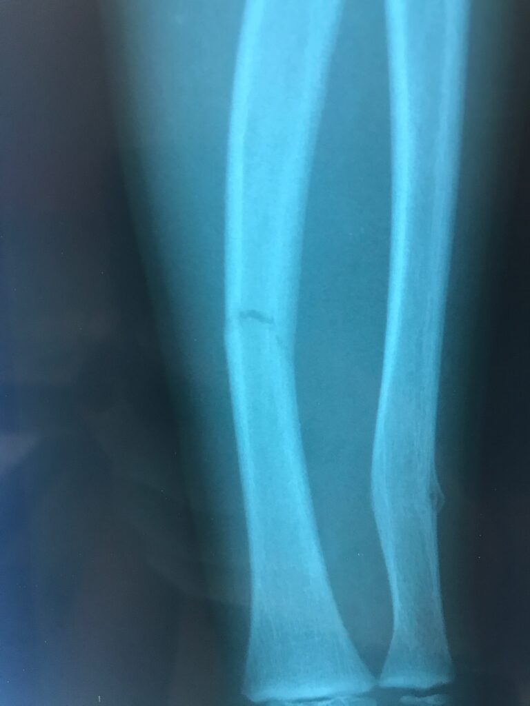
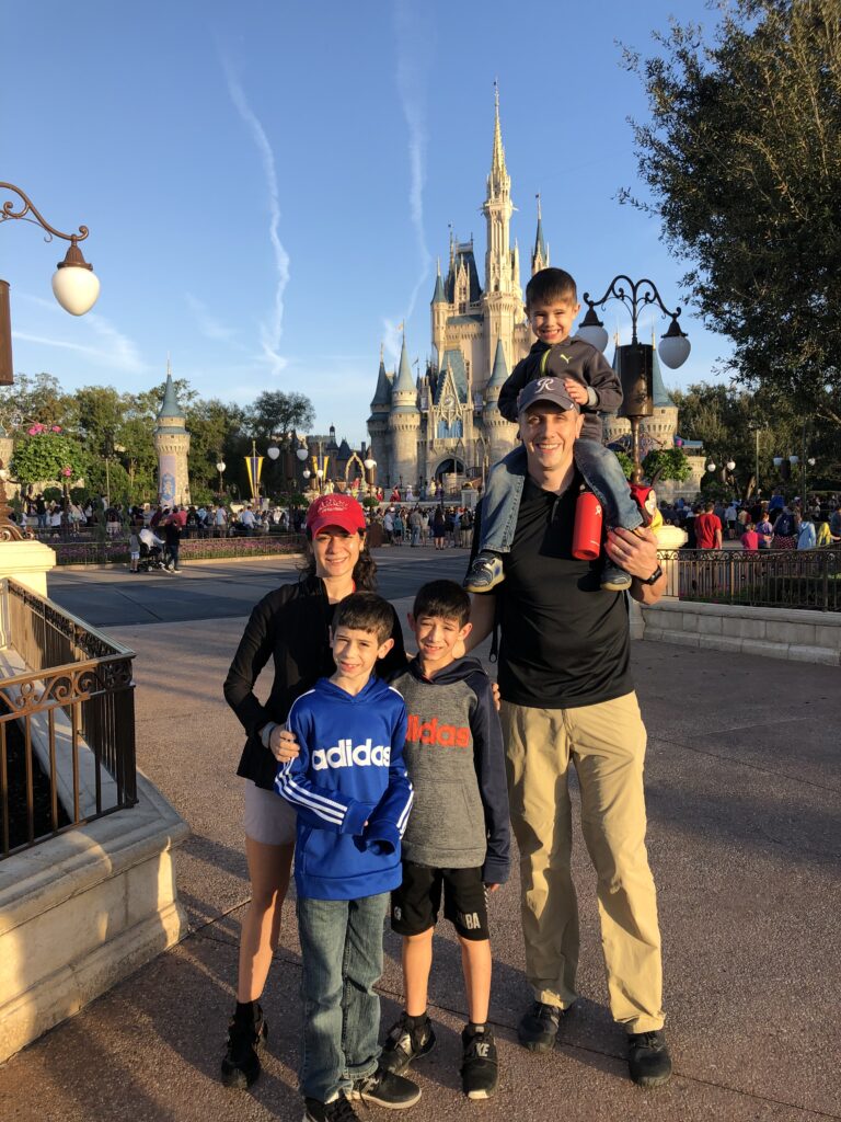
It is said that Walt Disney World is a land of adventures. Adventures, indeed. Consider, in particular, the adventure experienced by grandson number 2:
Right. What appears to be a fracture line in the ulna and a fracture-induced bulge in the radius is just that.
The course that led to this particular adventure began in the ordinary way. The first night we did the campfire sing-along and marshmallow roast.
Part of the “camping” ritual at Ft. Wilderness involves an infinity of activities, this one being a Chip ‘n’ Dale s’mores production and sing-a-long.
By 6:45 am the next day we were at the Ft. Wilderness dock for the boat ride to the Contemporary Resort, then the monorail over to the Magic Kingdom, then a morning of racing from place to place, doing the usual stuff, except that Chris was the only boy interested in Space Mountain.
Things begin as they should...
Eventually it was lunch, then back to the campground for a brief respite, with a plan to return later for more rides, then the fireworks show, and then to drag three depleted boys back to the campers.
But during the interlude back at the campground, we decided on an excursion to the nearby playground, which turned into some kind of a game wherein, for reasons only little boys can imagine, there was “hot lava” only on the highest parts of the play equipment, and escaping the lava required one to climb up to and then jump from the top or, in Chris’s rendition of that maneuver, jump from the top and then cushion the fall by landing squarely on an arm.
So, after a lengthy “is-it-broken-or-not” discussion among the grownups, all the time with Chris crying and insisting, correctly as it turns out, “I’m telling you my stupid arm is broken!”, Robert took the little guy to the emergency room and the rest of us did what all sympathetic family members would do under such circumstances, which is to say, we went back to the Magic Kingdom.
The untoward turn of events created something of a crimp in the plans, but (except for Chris, of course) not as much of a crimp as one might think. The remaining five of us still had a great time at the Magic Kingdom, culminating in the most amazing fireworks show that the world has ever seen.
It’s hard to describe, but animated images cover the entire castle, and the fireworks are choreographed to the images. And while all of this is happening, music appropriate to the images plays over the park’s loudspeakers, while tens of thousands of little children all sing along.
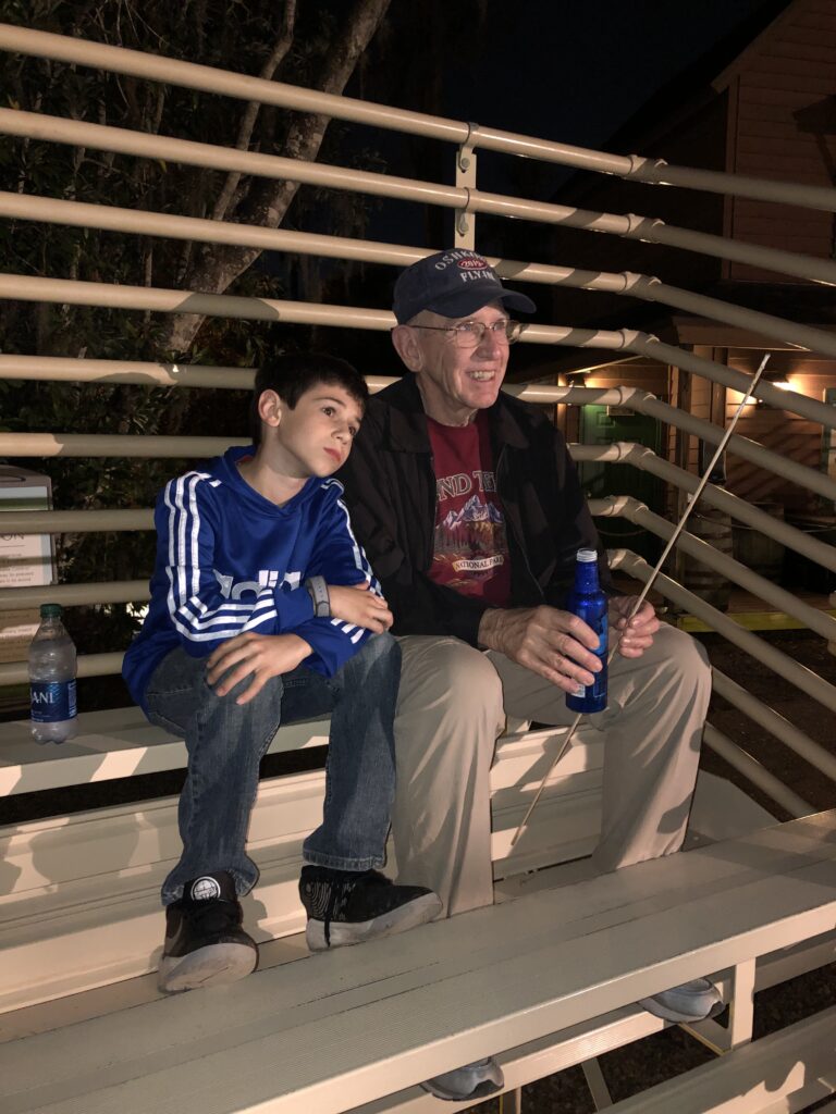
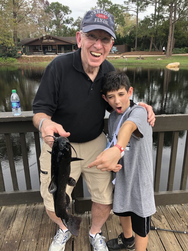
The next day was scheduled to be one hanging around the campground anyway, and even for a little boy with a broken arm there’s no shortage of things to do.
While the other kids were off at the pool, Chris and I spent a couple hours hauling fish out of one of the canals, including some remarkably large catfish. “Catching” the fish involved my holding the rod while Chris cranked away furiously on the reel. Not exactly artful, but it worked.
All things considered, it was another wonderful trip to Walt Disney World. As before, I’m amazed at how Disney, whatever it does, does it to a degree of perfection that one never sees anywhere else in our modern world of mediocrity. And, also as before, when I hear the carping of cynics who say that Disney is too commercialized, too artificial, too expensive, too American, or too whatever, I’m just glad that no such sentiments occur in this family. For all of us, Disney really is a magical place and, as was remarked to me by a visitor once before, “I guess if you’re not happy at Disney World, there aren’t a lot of places you’ll ever be happy.”
The last two posts summarized various aspects of this year’s Experimental Aircraft Association “AirVenture” gathering in Oshkosh, Wisconsin. A recent article in Flying magazine details the record-setting statistics for that event: “The Numbers Are in For AirVenture 2019.” Just to highlight a few of the most unbelievable metrics:
Total attendance was 642,000, an increase of 7%.
More than 10,000 aircraft were flown to the the event, resulting in 16,807 aircraft operations, an average of 127 takeoffs/landings per hour! [Compare this to Atlanta Hartsfield airport, which averages 91 operations per hour (2236 per day), and it’s supposedly the “busiest airport in the world.” Sorry, but not during the week of AirVenture it’s not!]
Besides the thousands of plain ol’ general aviation aircraft, there were 1,057 home-built aircraft, 939 vintage airplanes, 400 warbirds, 188 ultralights and light-sport aircraft, 105 seaplanes, 62 aerobatic aircraft, and 7 in an “other” category.
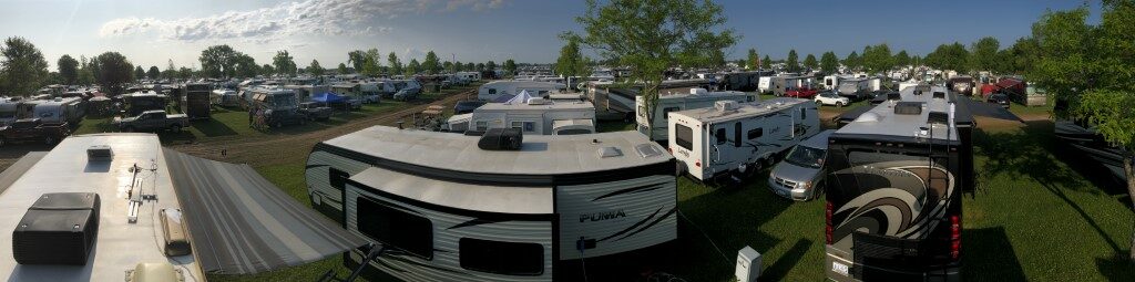
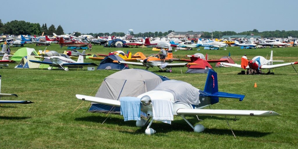
There were 12,300 camping sites (tent-, RV-, and airplane-sites), which together accounted for 40,000 visitors.
At one point, when I was grousing about the shortcomings of the camper registration process, I thought to myself, “If I were a decent person, I’d quit complaining and get out and help.” I should have. AirVenture relied on 5,500 volunteers who contributed more than 250,000 hours of volunteer time!
When we were talking to friends about what to expect at Oshkosh, I would often say, “Well, I’ve been to lots of airshows before…,” to which the response was always something like, “No, you don’t understand. This isn’t an ‘airshow.’ It’s an aviation experience in a completely different category from anything you’ve ever seen.” Truer words were never uttered.
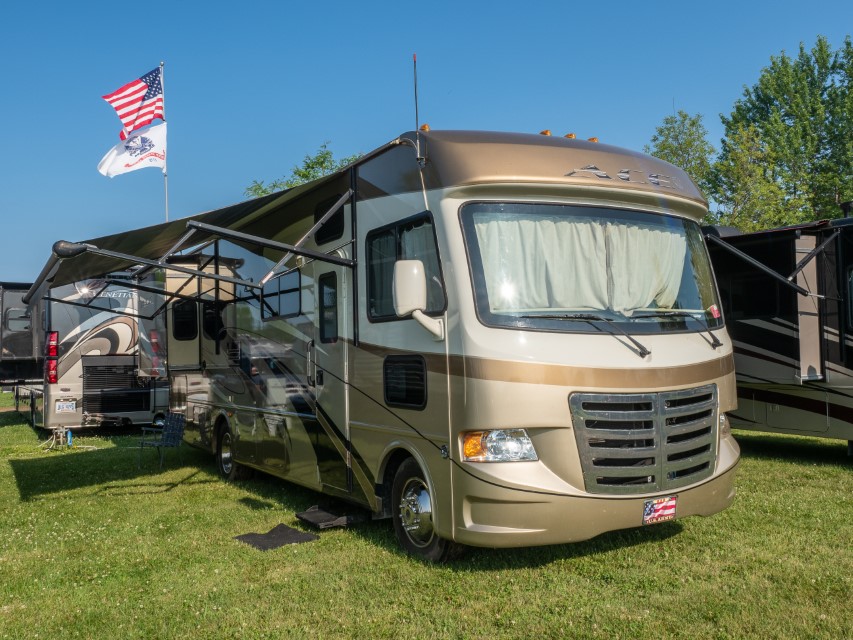
After loitering around for a day, waiting for EAA to give us an all-clear to head to the campground, and with nary a peep from Campground Central Command, we decided to head on over and take our chances. Good call. The campground was open, although in the throes of thousands of like-minded campers all converging on the airport at the same time, and after 4+ hours of creeping along at a turtle’s pace in the camper registration line (which is baffling since we were pre-registered), we finally made it to the campground and got set up.
It’s easy to have mixed feelings about the campground: there are (literally) four thousand (!) campers, all jammed together elbow to elbow, with no amenities (or even shade, for that matter), which creates an environment like what you’d expect it would create. But, all of that pales in comparison to the convenience of walking just a fraction of a mile to the flight line, displays, and everything else that AirVenture has to offer. So, even with EAA’s conspicuous campground management deficiencies, we decided that staying in the campground is definitely the way to go.
And AirVenture is everything we were told it would be, and more. It really is hard to convey the atmosphere of a place where over the course of a week, there are 600,000 airplane kooks flying around, walking around, lounging about, visiting exhibits, and watching airshows, interspersed with nearly a thousand vendors, and God-only-knows how many displays, programs, and seminars. We were in and amongst this AirVenture frenzy for two-and-a-half days, and saw only maybe a tenth of what there is to see, and only half of the activities we had flagged as things we definitely wanted to do. I have thousands of pictures trying to capture the feeling (don’t worry, I’m not going to post them all), but understand that all of what follows falls woefully short of adequately communicating the experience.
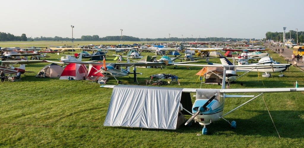
The first thing one notices is that this is not just an airshow; it’s a pilots’ convention. Many of the attendees flew here in their own planes, and the assortment of aircraft is as varied as you’d expect for a group named the “Experimental Aircraft Association.”
The General Aviation area has all the popular private aircraft, with parking (and camping) areas like this going on for hundreds of yards in multiple areas.Aficionados of particular makes, such as these 1930s-era Beech Model 17 Staggerwing biplanes, a model that was eventually done in by the Bonanza, all park together.Acres and acres of home-built “Experimental” aircraft.As well as a full complement of several hundred float planes.
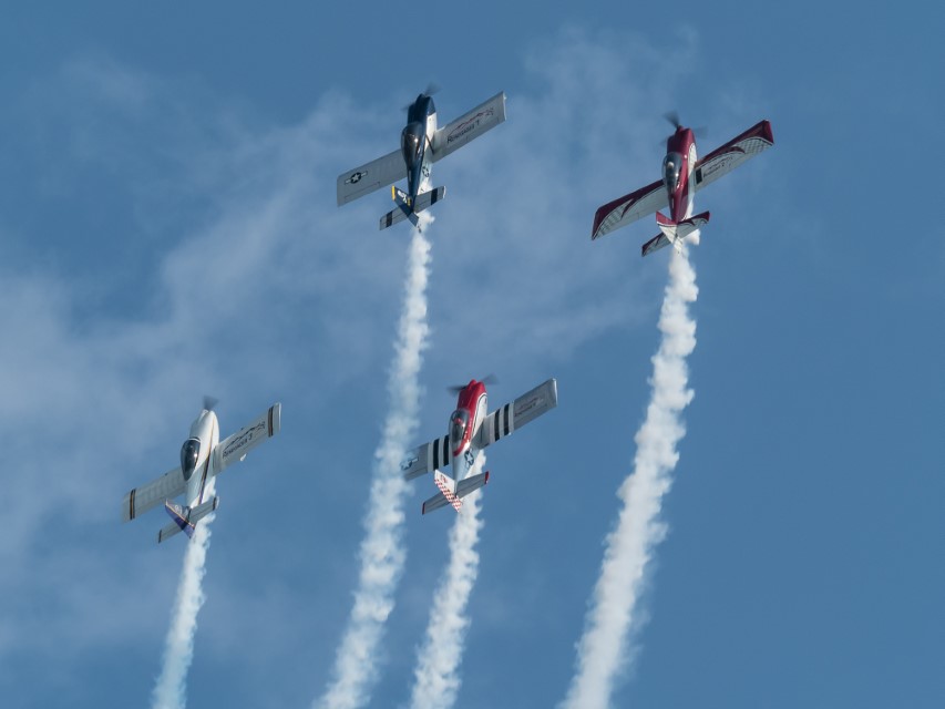
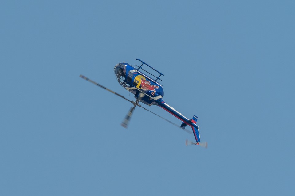
Of course, Airventure also included four hours of air shows every day, featuring not only aerobatics but demonstrations and flights of a wide variety of aircraft.
Twin Tigers (Yak-55s)Rocky Mountain Renegades (flying Van’s RV-8, Van’s RV-4, Giles G-202)Red Bull: Kirby Chambliss in Edge 540The announcer claimed that there was something about this Red Bull MBB Bo 105 helicopter that gave it special capabilities. No matter. It was still terrifying to watch a helicopter do not only loops and rolls, but front- and back-flips.The legendary Patty Wagstaff (in her Extra 300S), three-time National Aerobatic Champion (!), slicing the ribbon, inverted, at about 20′ high.
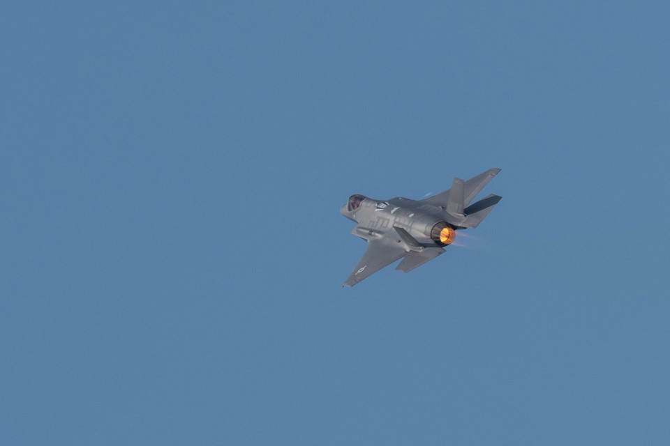
And there were a large number of military demonstrations…
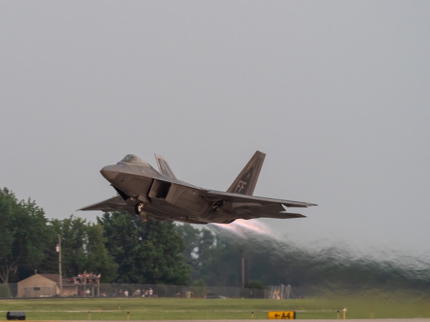
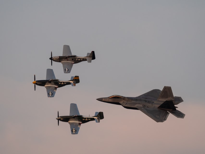
F-35 Lightning II. The U.S. stated plan is to buy 2,663 F-35s, which will provide the bulk of the crewed tactical airpower of the U.S. Air Force, Navy, and Marine Corps in coming decades. Deliveries of the F-35 for the U.S. military are scheduled until 2037 with a projected service life up to 2070.F-22 Raptor. Originally, 750 F-22s were to be purchased. However, in 2009, the program was cut to 187 aircraft due to high costs, a lack of clear air-to-air missions, a ban on exports, and development of the more versatile F-35. The last F-22 was delivered in 2012.F-22 Raptor being escorted by three World War II P-51 Mustangs. There were dozens of warbird aircraft present, and what’s amazing is all of them are privately owned, restored and maintained by private individuals purely to assure that this country’s heritage of vintage military aircraft remains available for future generations.
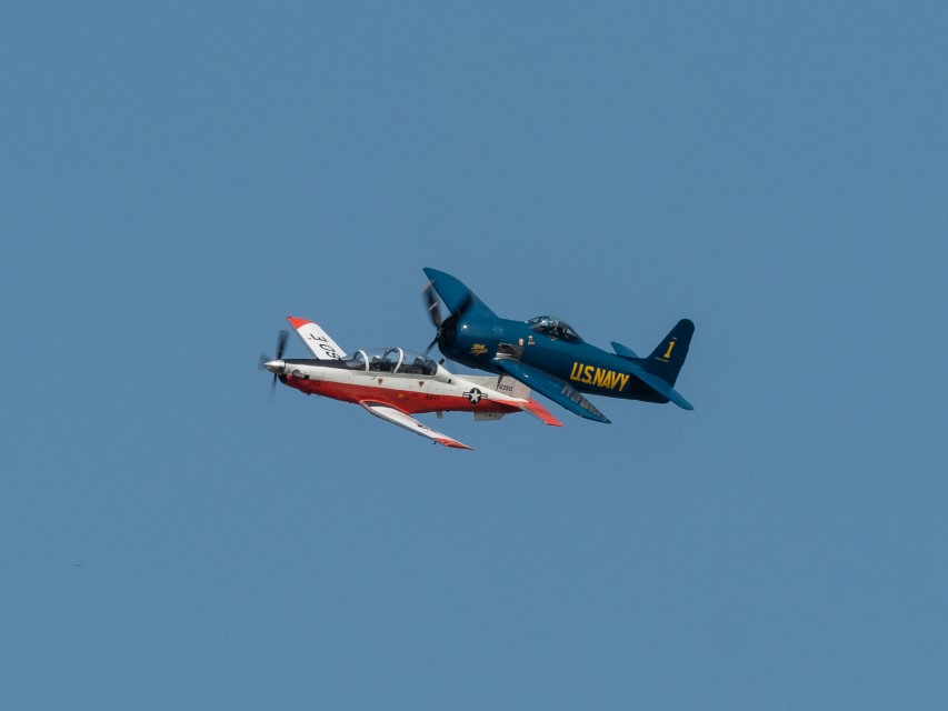
The military aircraft, though, we’re limited to the hair-on-fire fighters. This year’s airshow included a special series of flights by military training aircraft…
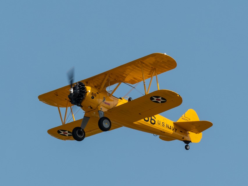
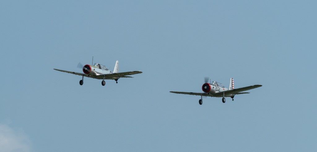
A Stearman PT-17, the airplane of choice for naval aviators’ first introduction to flight during World War II. My father received his initial training in one of these.A pair of AT-6 Texans (although the Navy called them “SNJs”), the advanced trainer during World War II, after one graduated from the PT-17. My dad also trained in one of these.A doubly special moment: a Beechcraft T-6 Texan II (the current Navy trainer) flying alongside an F8F Bearcat (one of the last fighters made during the World War II era).
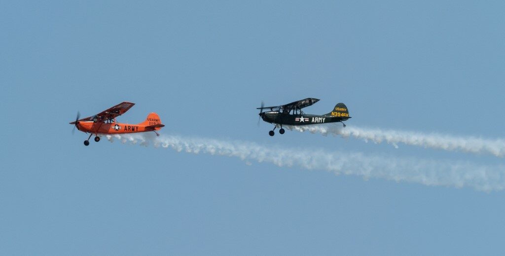
… and besides the trainers, AirVenture also featured flights of little-heralded, but extremely important “observation” aircraft, mostly used to spot enemy positions and call in hell’s fury on top of them, something that gives me a nice warm feeling in my heart.
A pair of O-1 “Bird Dog” Army aircraft. During the Vietnam war, these planes were used for reconnaissance, target acquisition, artillery adjustment, radio relay, convoy escort and the forward air control of tactical aircraft, including bombers.
A highlight of the show was the aerial firefighting demonstration:
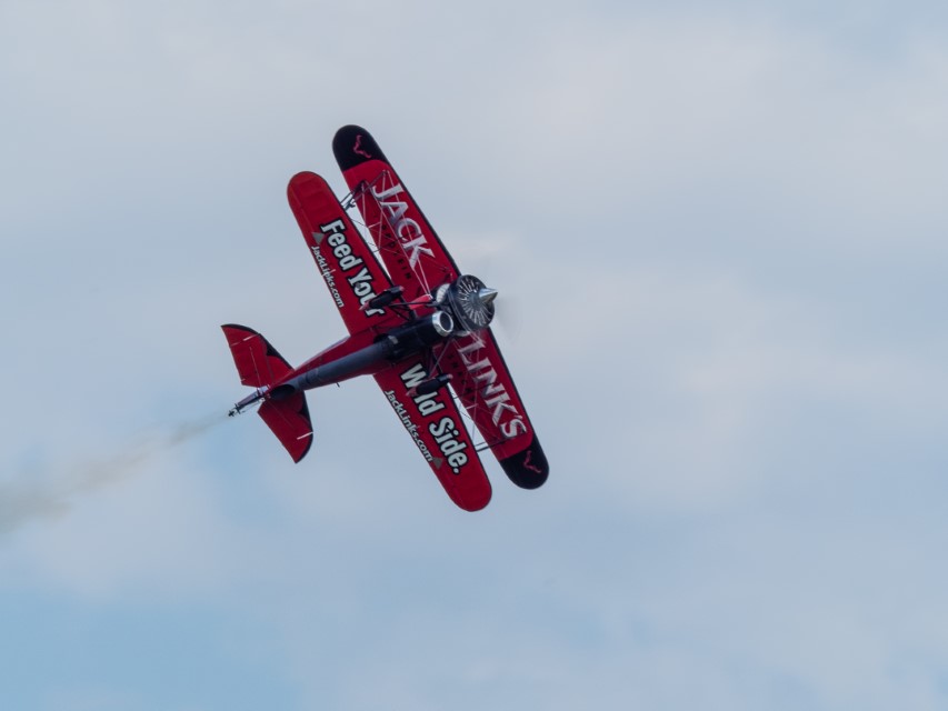
Besides all this, there were also demonstrations by aircraft that, well, defy understanding by normal people.
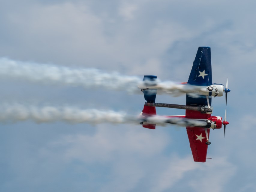
This guy, for example, took an old barnstormer biplane and for some reason, mounted a jet engine on the bottom. “Wild Side” indeed.Not to be outdone, these guys took two Yak-55 stunt planes, welded them together in the middle, and then mounted a jet engine under the center section.
But this is the weirdest:
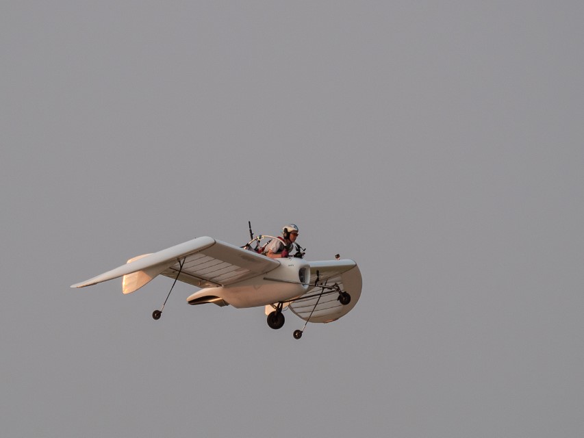
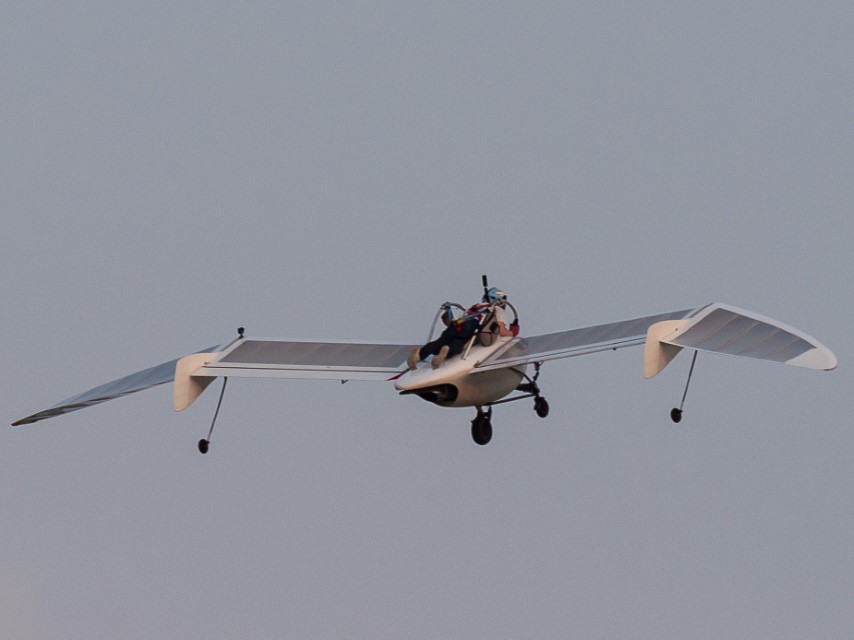
This is some guy flying around on a jet-powered contraption that looks for all the world like a decapitated seagull. And you might notice he looks somewhat nervous. Here’s why…… this guy is actually laying down on top of the wing, strapped on, I’m sure, but obviously holding on for dear life nonetheless.
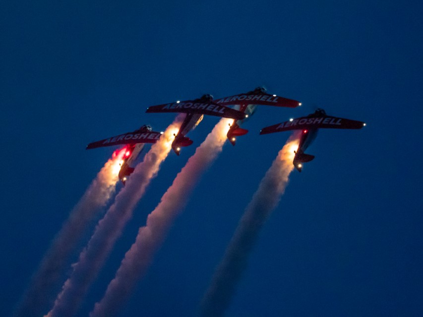
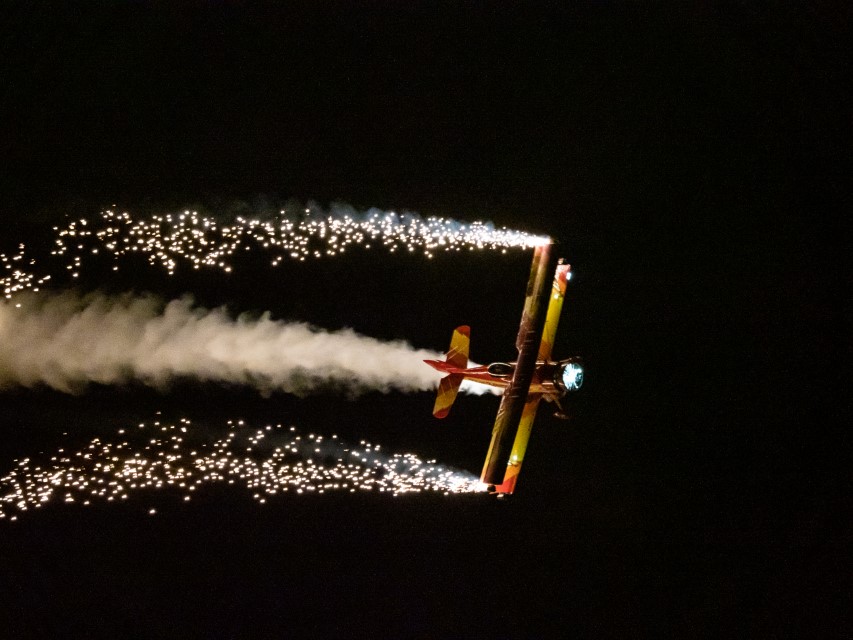
But the real highlight of the show was the night airshow.
The Aeroshell demonstration team performing close formation aerobatics at night.More of the pyrotechnics that characterized the night air show.
I have probably been to over a hundred airshows in my life. As a kid, I grew up at airshows, and air races, and airports, and air-everything. Nothing in my life prepared me for this.
Just one concluding thought. If one is an airplane nut-case, Oshkosh is a little piece of heaven on earth. But it likewise holds a parallel appeal even to normal people: this is also a gathering of people who just love America, who support the military, and who aren’t hesitant or embarrassed by conspicuously patriotic celebrations. Every afternoon show began with the National Anthem, and everyone (as in “everyone”) stood, removed their hats, faced the flag with their hearts covered. Essentially every event, every performer, every display included some kind of a stated thanks to current and former military members, without whom (it was always said) as a country we would have nothing. At one point, Wendy (who is by no stretch an airplane devotee) looked at me during one of the more patriotic moments and said, “These are our peeps…” True, true.
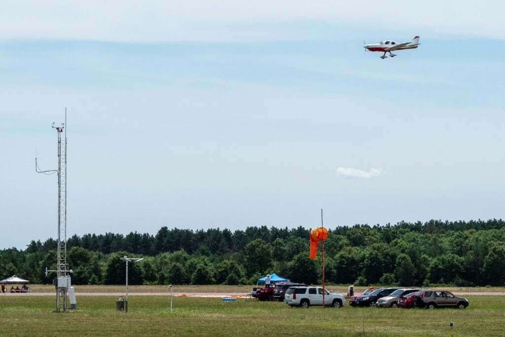
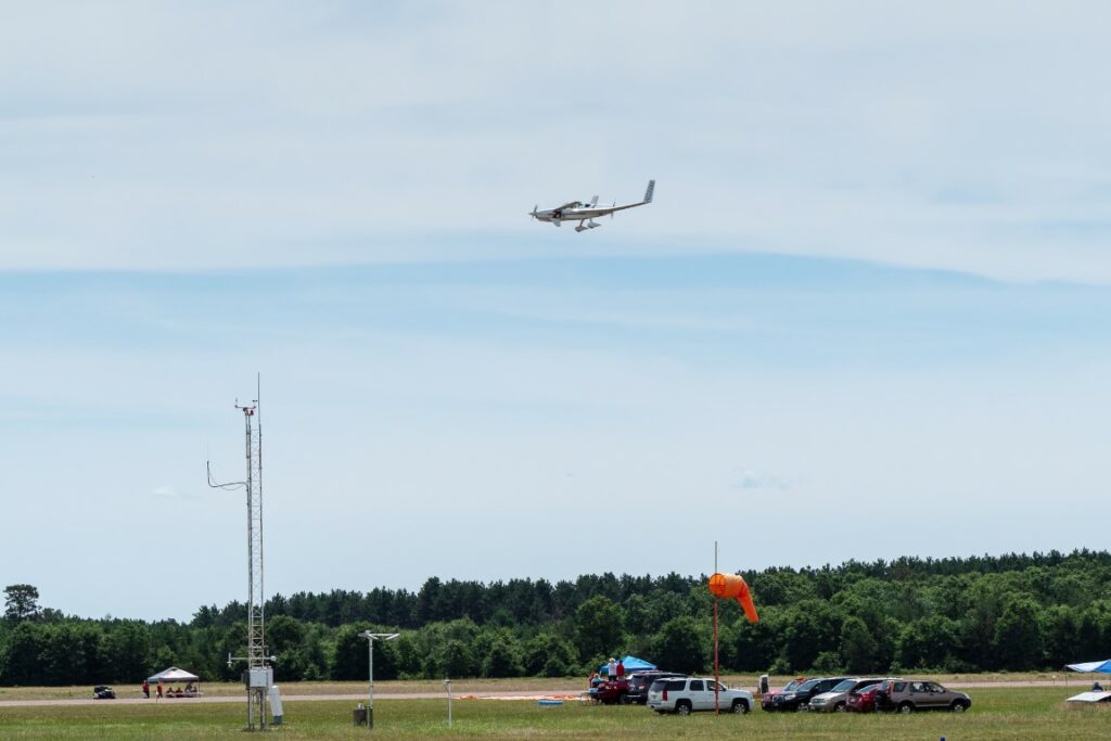
For anyone not familiar with it, “AirVenture” is an annual gathering of aviation enthusiasts in Oshkosh, Wisconsin, but that doesn’t begin to describe how over-the-top crazy this event is. Imagine an airshow with all of the usual aerobatics and stunt-flying, except that the airshow is attended by about 600,000 people, many of whom fly to the airshow in airplanes they built themselves, and who spend the week sleeping on the ground under the wings of their aircraft. And during the same show, the military takes advantage of the opportunity to show off its latest hardware. And all of this is held at “Whitman Regional Airport” in Oshkosh, Wisconsin, a dippy little two-bit airfield that, incredibly, for the week of the airshow actually becomes the busiest airport in the world. During the week of AirVenture, the airport will see 10,000 aircraft, 3,000 show planes, nearly 1000 journalists, and 900 commercial vendors. Besides gawking at airplanes, there are hundreds of seminars for the attendees, with topics ranging from the latest aviation technology to (no kidding) “How to hand prop your aircraft,” which I think means starting the engine by grabbing the propeller and giving it a good yank, getting out of the way before the propeller slices you to ribbons.
Seeing as how I’ve basically been an aviation aficionado my whole life, AirVenture is a major bucket list item for me. So Wendy and I are here to spend a few days immersed in aviation excess.
But life is not so simple. Just before we arrived, a major weather system passed through, leaving our camping area at Whitman Field a soggy, impassable, mud bog. So, we’re stuck in a nearby campground, waiting for things to dry out enough to get to Oshkosh.
So, we spent today, first, killing time at a different airport, sitting at the finish line for air races where guys take their own airplanes and, just for the fun of it, see how fast they will go.
A home-built Lancair (I think) dives for the finish line with wide-open throttle after flying 431 miles from Mt. Vernon, Illinois, to Stevens Point, Wisconsin.
A home-built “Long-EZ” crosses the finish line. Besides having a weird pusher-puller arrangement of propellers, the swept wing in the rear combined with a canard in the front makes some people (like Wendy, for example) think that the airplane is flying backwards.
So, after a couple hours of watching planes (either fascinating or boring, depending), and with Oshkosh still closed, we decided to explore a bit of central Wisconsin. A friend had suggested the International Crane Foundation in Baraboo, but it’s closed for renovations for the entire year. Wendy read a short blurb about the Dells of the Wisconsin River nature area, and we always enjoy hiking, so it’s off we go!
A-a-a-a-a-r-g-h!!! Somehow we missed a turn and ended up in the town of Wisconsin Dells. Words cannot even begin to convey the vulgarity of that locale. Billing itself as the “water park capital of the world,” the city has more water parks than any other city in America. The experience is so demoralizing that the only way to convey its full effect is to labor through the details of it all. In the span of a few blocks, one is confronted with:
The Mount Olympus Water and Theme Park (three hotels serving a 300-acre outdoor and 120,000-square-foot indoor water parks, with more than 40 waterslides, plus eight go-kart tracks, seven roller coasters, a large wave pool with 9-foot waves, lazy rivers, and hot tubs).
Noah’s Ark Water Park (the Flamingo Hotel, serving what is billed as America’s largest water park, 70 acres of waterslides, pools, rivers, bumper boats, surfing experiences, arcades, a 4D dive-in theater, a water coaster, slides, swings, water cannons, along with 12 eateries and bars).
Kalahari Resort (750-room hotel with indoor and outdoor water parks with multiple slides, lazy rivers, activity pools, wave pools, including a Ferris wheel, African-themed carousel, ropes course, climbing walls, go karts, bowling, mini-golf and arcade games).
Great Wolf Lodge (80,000-square-foot indoor water park, with 6 slides, rivers, activity pools, hot tubs, kiddie pools, a four-story water tree house, and the Howlin’ Tornado, a water slide “thrill ride”).
Wilderness Lodge (600-acre, also billed as America’s largest water park resort, with four indoor water parks, three outdoor water parks, a large outdoor pool area, indoor go karts, a lazer maze, a ropes course, bumper boats, mini-golf, a kids’ club, arcades, the Klondike Kavern, with its two, five-story tube slides, and the Wild WaterDome, America’s largest indoor wave pool).
And so on and so on. It never ends. You get the point. Except you don’t. As if this isn’t enough, in and amongst all this are go-kart tracks, t-shirt shops, junk food dispensers, souvenir shops, and an unimaginable array of the most ghastly, grotesque, garish architectural nightmares on earth. The “Rome Hotel,” for example, is an ersatz replica (or maybe caricature) of the Roman Coliseum.
That’s enough. No, it’s not. One more point. You might think such an area is so repulsive that it would be empty, devoid of people, like those creepy photos one sees of abandoned amusement parks. Wrong again. The area is packed, crammed, jammed with people standing in pools, elbow to elbow, in whatever microbial soup exists in these communal pools, which almost certainly includes E. coli, Ebola, and flesh-eating bacteria. Thousands of people, everywhere you look. It’s like Manhattan, only wetter.
Somehow, we managed to maneuver our motor home through the traffic, and out of this little piece of hell on earth, and back to our campground. The Oshkosh campground is still closed, and unfortunately we didn’t tow our car along with us, and all of the rental car agencies within 50 miles are sold out, so I’m not sure what’s next. But it certainly doesn’t involve Wisconsin Dells.
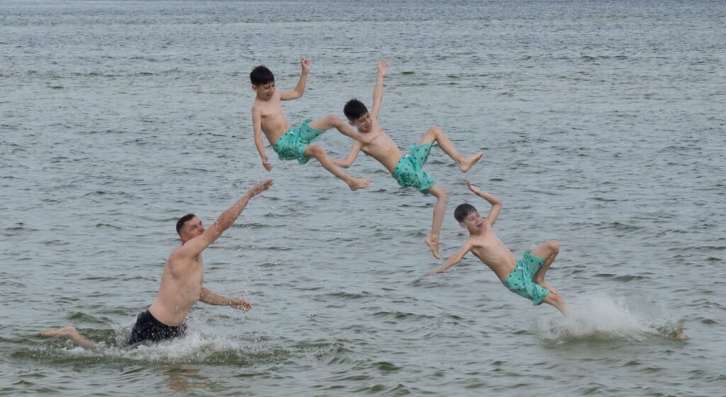
After a quick drive to Pensacola Naval Air Station, where Robert had reserved a pair of adjacent sites in a great campground on the base, we had time for afternoon play in the Gulf.
The inevitable combination of a big, strong dad and a small, skinny, imminently tossable little boy is, well, as shown above. (It’s hard to tell from his facial expression if this is really fun or really scary. Doesn’t matter. Either way, it’s a launch to an altitude sufficient to present a risk of burning up in reentry.)
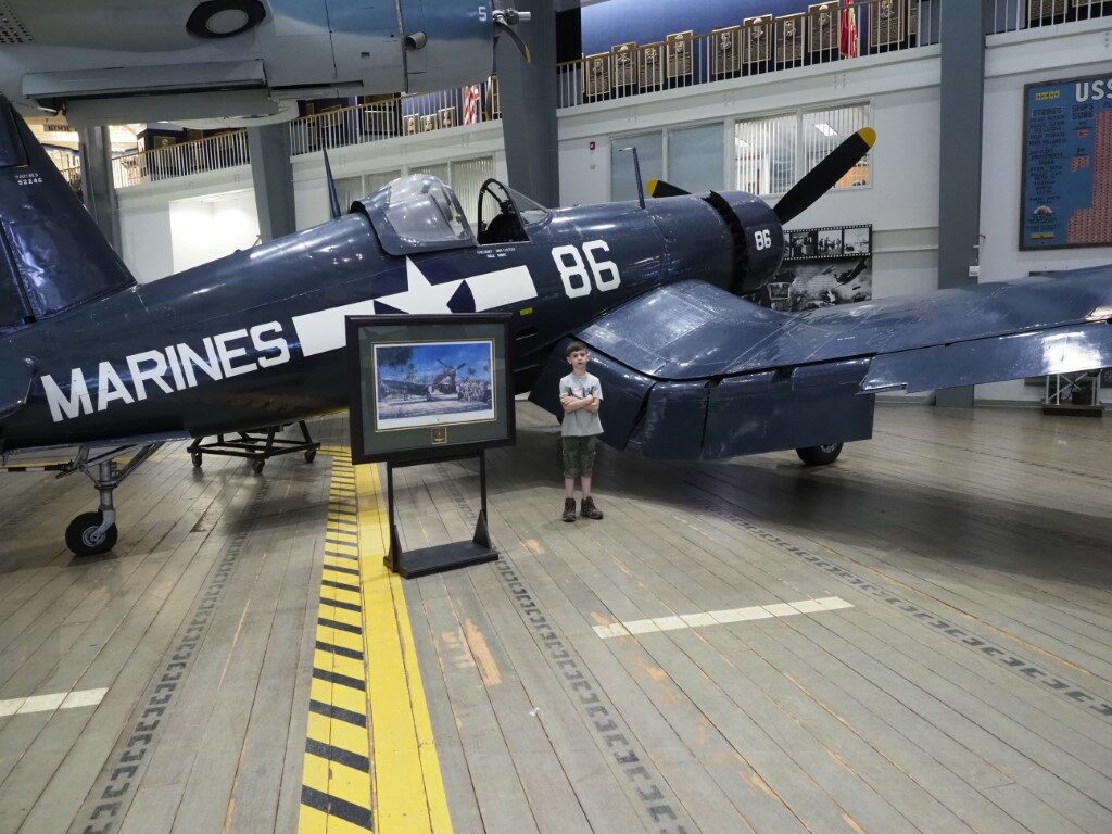
Next day, though, was the big day: a morning at the Naval Aviation Museum. We’ve been here many times before, but it’s always special. There are numerous World War II naval aircraft in the museum’s collection, and most of them figure prominently in family lore.
An F4U Corsair, of the type that my dad flew in World War II. I once had a letter he mailed back to my mom with a photo of an aircraft very much like this with the caption, “Yes, the Navy sometimes lets the Marines fly them.” Apparently, the museum agrees.
I repeated some of the stories my dad told me about flying the Corsair, most notably how it earned its reputation as an “ensign killer.” The combination of a long nose that obscured the carrier on approach (which necessitated a turning approach to the ship, straightening out only at the last moment), plus a 2000 horsepower double-radial engine so powerful that a clumsy hand on the throttle would torque-roll the aircraft, meant that flying a Corsair onto the deck of a pitching carrier was not something to be undertaken by the inexperienced. At least not twice.
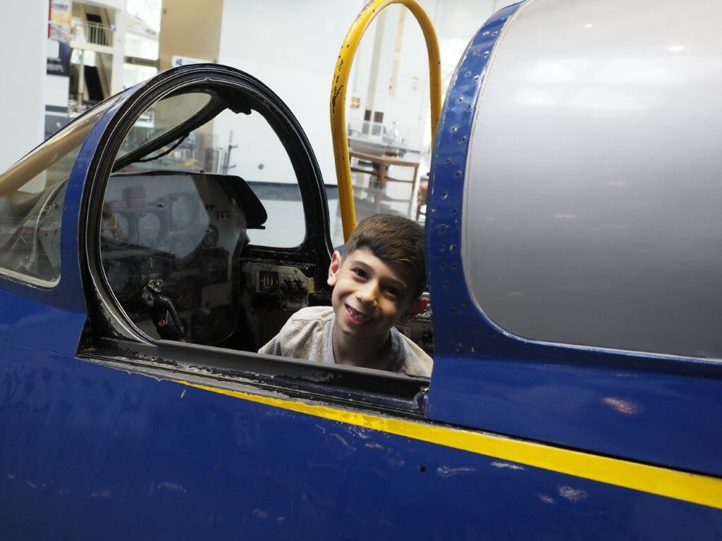
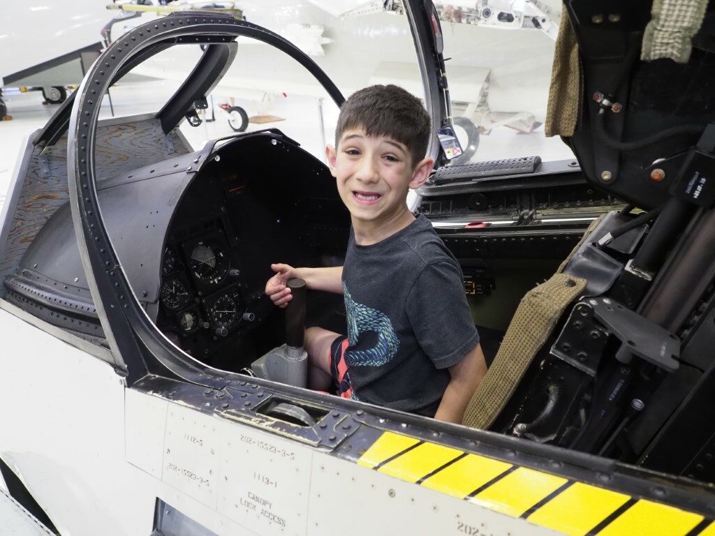
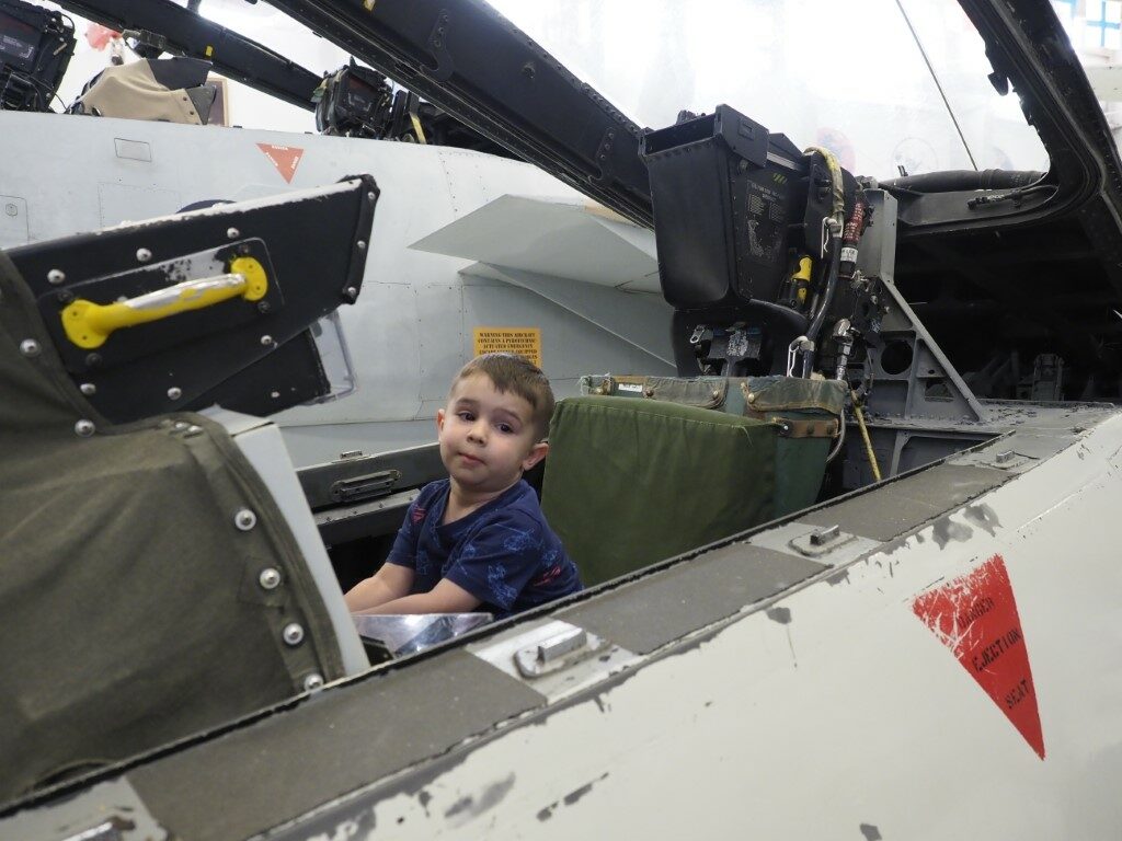
Plenty of opportunities to climb into a cockpit... And another……and another.
Then back to the campground, more beach time, a wonderful dinner of ersatz Chick-Fil-A homemade chicken sandwiches, and then evening playtime at the beach catching ghost crabs. (Which causes one to wonder: why does the following exchange occur in real life? “Ow, ow, it’s pinching me!” “Then put it down.” “No. I don’t want to.”) Maybe there’s some genetic remnant of an evolutionary ancestor that explains such things. Something to think about someday…
Next, off to Yogi Bear Jellystone Park (seriously?) before the last push to Tampa.
At long last, the Washington emigrees made it to New Orleans and we met up with them (rather inauspiciously in a WalMart parking lot) and headed to the campground at the New Orleans Naval Air Station for a couple days. We spent the first afternoon tending to an electrical matter so that they could have a working air conditioner (an important feature of “camping” in southern Louisiana), and then had to make plans for the following day.
The original plan was to take to the boys to the World War II Museum, but based on our impressions, and after a discussion with Robert and Laura, we decided the boys would profit more from the experience if they were a few years older. So, what else to do? Tour New Orleans cemeteries? No. Sample some cajun fare? No. Visit some jazz clubs? No. The “other kind” of clubs? Probably not for a few years. Swamp excursion? Nope. Maybe a “Confederacy of Dunces” tour? (There actually is a statue of Ignatius J. Reilly somewhere in New Orleans.) Don’t think a two-year-old would appreciate the literary significance of that tour.
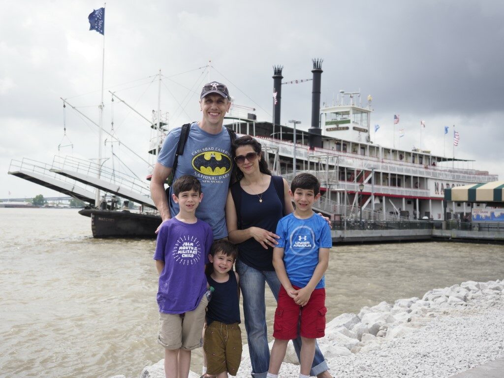
Finally, Robert and Laura hit on the perfect solution: a tour on the riverboat Natchez, along with a buffet lunch aboard. Perfect for little boys and, actually, pretty interesting for the grownups as well. The most grownup-engaging part of which is that we actually got to tour the engine room. Except that the boiler is power by diesel fuel instead of coal, these are the real thing: huge steam-driven push-pull pistons driving the two arms of the paddle wheel, with no supplemental drive (i.e., no “cheating” with propellers).
Ready to board the paddlewheeler Natchez for a three-hour long tour on the Mississippi. The only downside: the boys all know by heart the lyrics to “Battle of New Orleans” (“In 1814, we took a little trip…” and all that), and when the narrator for the tour announced we were passing the site of the battle of New Orleans, it set off a rendition of the hit that lasted, well, for a while.
Then back to the campground for a quick trip to the PX for haircuts (technically the NEX), then back to several hours of the boys doing drag races and 100-yard dashes on the campground road.
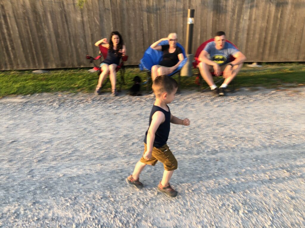
Little Michael, racing across the finish line, having activated with jet-assist super powers. (He’s moving so quickly, the motion blur in this photo is authentic!)Christopher doing trick-skids as he crosses the finish line. As you can see, the crowd is roaring with approval.
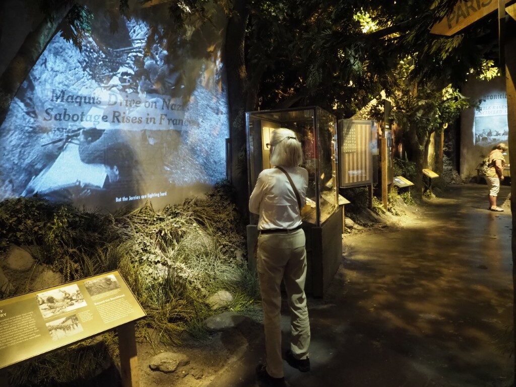
We’re depleted. We’ve spent the past couple days at the National World War II Museum in New Orleans. This was a bucket list item for both of us and was supposed to be a stroll through a period of U.S. history that both of us could relate to, me because of my dad’s role as a Navy pilot in World War II, and Wendy’s because of her dad’s role as a B-17 pilot. Easy-peasy, connect with our parents’ era, see some exhibits, maybe see a 1940s musical show, and wait for Robert and family to show up in a couple days.
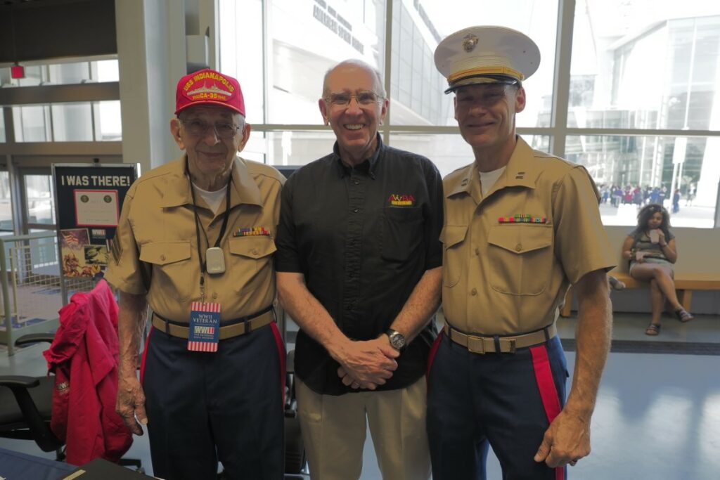
Things started off on a particularly high note. We had the honor of meeting the last surviving crewman from the U.S.S. Indianapolis, Sgt (fmr) Edgar Harrell, and his escort, Marine Capt (fmr) Donald Montefusco, and got to spend an hour chatting with them about those fateful days in 1945.
After delivering the “Little Boy” atomic bomb to Tinian Island, the Indianapolis departed for the Philippines. On July 30, the ship was hit by torpedoes from a Japanese sub and sank within minutes. Of 1200 crewman on board, 300 went down with the ship. The remaining 900 went into the water and faced starvation, dehydration, and salt water poisoning, and those who survived that were ravaged by shark attacks while they waited for 4 days to be rescued. In the end, only 316 survived, including Sgt Edgar Harrell, at left.
Then it was off to the first exhibit: the “Arsenal of Democracy,” describing how America geared up for the war effort. Mussolini mocked America, saying that all we could do was to make refrigerators. Well, Benito baby, as Eisenhower said, there is no force on earth like that of a democracy enraged, and it’s a surprisingly small step from a refrigerator to a bomber, and when America created a “war production board” to oversee conversion from consumer goods to war materiel, Mussolini and his Axis cronies learned first-hand exactly what America’s “refrigerator” factories could do: 108,000 tanks; 97,000 bombers; 100,000 fighters; 24 aircraft carriers; 324 destroyers; and 100 billion (that’s billion, with a “b”) bullets. Add to that 15 million men and women in the armed forces. Oh, and in our spare time, we developed the atomic bomb to vaporize the little Axis creeps in the Orient. So far with the museum, we’re pretty good, so with that exhibit done, we were off to the D-Day exhibit.
At this point, though, the nature of our museum experience changed dramatically. The stunning might of the American response occurs in the context of human carnage of an unimaginably horrific scale. The museum experience begins with a film, narrated by Tom Hanks, that recounts the death tally, country-by-country, as a result of the war, for a total of 65 million people dead. And in every museum exhibit, the human cost of this war is clearly and graphically displayed, often in gruesome photographs, videos, and statistics. Over 400,000 Americans died responding to the evil of the Axis onslaught, and the museum does not downplay that terrible cost.
But the museum’s message is not just about the horrors of World War II, but also the heroics of it all. Indeed, in many ways, the museum is more about the unspeakable heroism of ordinary Americans than anything else. As Stephen Ambrose once made clear, at the start of World War II, it was far from clear that a bunch of farmers, teachers, policemen, and clerks could take up arms and successfully overcome an army of battle-hardened professional soldiers. These weren’t guys who were trained to fight. They were just ordinary people who responded when their country called and resolved to do their best. And somehow, out of the ordinary humanity of decent people, there arose the most powerful fighting force the world has ever seen. Throughout the museum, there are the stories of these ordinary guys doing the most daring, selfless acts of bravery one can imagine. And they’re largely not anyone special; they’re just guys doing their job. Millions of them. Over and over and over. Many times, the stories were so overwhelming it was, for me, actually hard to breathe.
We started off with the hall dedicated to D-Day. When the museum first opened in 2000, it was known as the National D-Day Museum, and it was not until 2003 that Congress declared the concept should be expanded to a National World War II Museum. It is the nature of the way Wendy and I travel that we read every display, listen to every audio, and watch every video. As a result, it took us fully five hours to work our way through the D-Day experience.
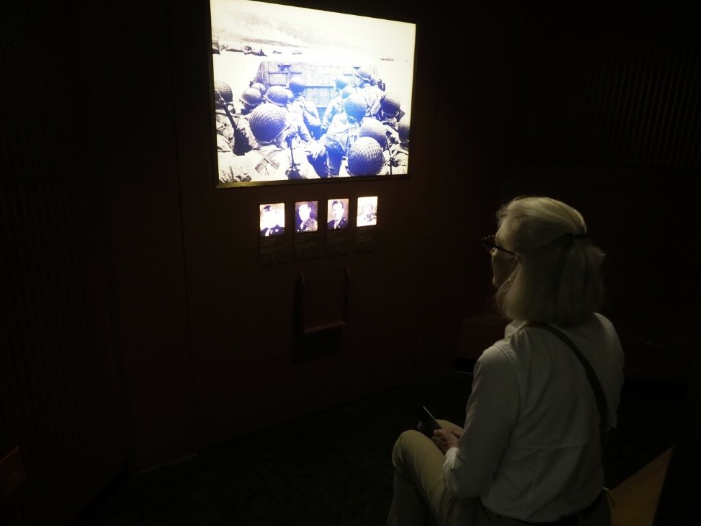
Throughout the museum, there are places where one can sit and listen to soldiers recount their personal experiences. Here, we are listening to men describe that moment when the ramps on the Higgins boats were dropped and they were thrown in the defenses of the German “Atlantic Wall.”
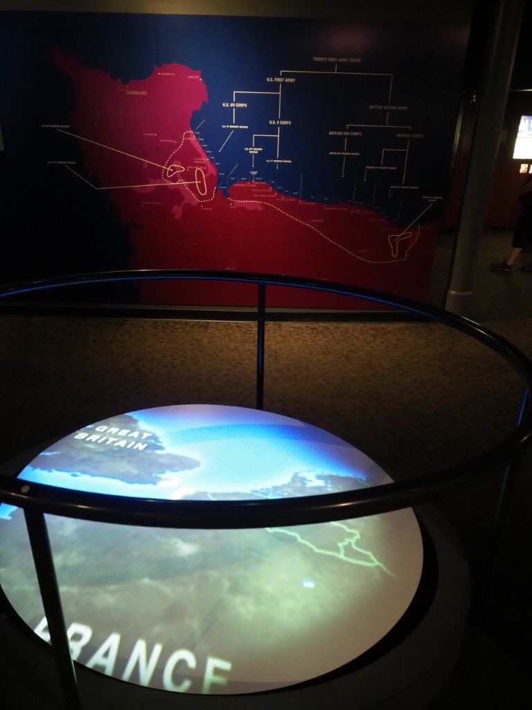
At one of the multi-media displays, a map of the Normandy landing areas is displayed with an animated depiction of each units progress on the beach.
And so it went, exhibit-by-exhibit, through the entire progress leading up to, during, and in the weeks following June 6, 1944. Even that event, though, is presented in a stark and foreboding context: on that fateful date, while Americans had seen some victories in expelling the Germans from North Africa, and were moving mile-by-mile up through Italy, and had some victories in the Pacific, the entire world, save for a few small areas, was overwhelmingly in the grip of dictatorships. Knowing how this all ends, it’s easy to forget what we were up against, and to forget that the end was never certain, a point that the museum makes clear throughout.
The next day we returned and, after a seeing a couple smaller exhibits, it was off to one of the newly added halls, “The Road to Berlin.” Same deal: one display after another of the stark combination of horror and heroism.
The museum’s exhibits are fully “immersive,” recreating in this instance the forests of France, the sounds of artillery, and the yard-by-yard battle for every mile of advance.
By the end of our experience in the Road to Berlin, we were pretty much exhausted. There was only an hour left before the museum closed, and we hadn’t even started “The Road to Tokyo,” the battle for the Pacific. But we couldn’t. We were too emotionally drained and didn’t have enough time to see the exhibit in our way anyway. So we’ve saved it for another day.
After all of this, one thought kept coming back to both of us. Could America ever do something like this again? Is there enough dedication to our country, as a country, that millions of men would sign up motivated only by a sense of national duty? Do the citizens of America have the character to put their lives on the line to save others? Are we physically and mentally capable of prolonged periods of deprivation and misery to sustain this kind of effort? We don’t know. Maybe. One hopes so. But the museum experience was a glimpse into an era where America was all that and more. And we’re glad we spent a couple days here. We’ll be back.
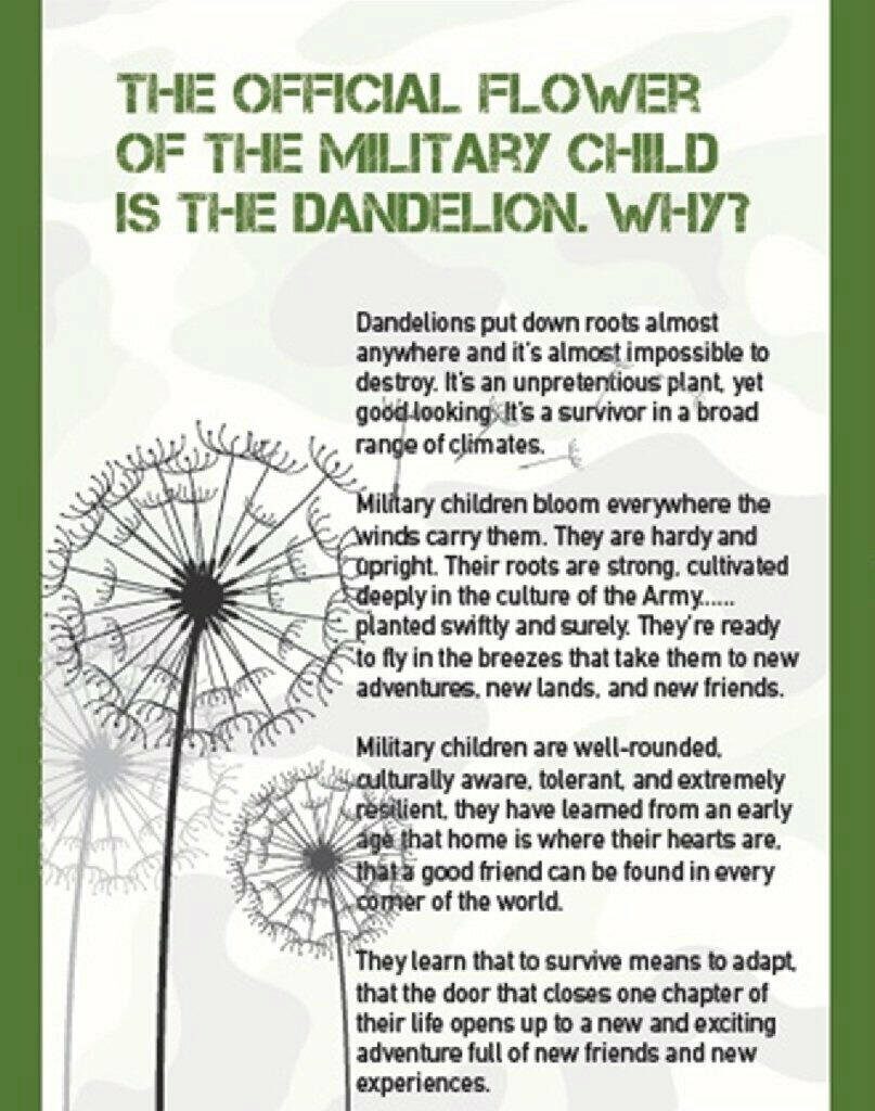
One of the extra added benefits of military service, besides being overworked, underpaid, sent off to God-forsaken hinterlands for months at a time, and having people try to shoot your fanny off (sounds pretty good so far, eh?) is that every couple years, you get to uproot your family and drag them off to some area of the country where they get to start their lives all over again. And because everything in the Army has to be described by a TLA (“three letter acronym”), this pick-up-and-move ordeal is known as a PCS (or “permanent change of station”). (As opposed to TDY (“temporary duty”), which is where you abandon your family for some period of time, and which further shows that everything in the Army must have a TLA, even two-word expressions. Go figure.) Besides the fact that there are hundreds of thousands of military families going through this process every year, what’s doubly amazing about it is that somehow military families not only rise to the challenge, they largely show the fortitude to make it a virtue. Like this:
(…from Laura’s Facebook page)
All of which is a long way of getting to the point: Robert, Laura, and the boys are, as I write this, in the process of PCS’ing from Seattle to Tampa, Florida.
Because they are who they are, though, they are once again “PCS’ing with style.” All five of them, plus a poodle (don’t ask), with whatever belongings they’re toting with them to avoid their being destroyed by Army movers, and towing their trailer, are meandering diagonally across the country, camping and seeing the sights along the way.
Roughly 4200 miles from Dupont to Tampa, with 22 days of seeing much of the best that this county has to offer along the way.
As you might expect, Laura has the boys studying in the truck between stops, getting their Junior Ranger badges at each stop, and somehow making sure that three boys and a dog crammed into a four-foot wide space for three-plus weeks don’t kill each other.
So, our plan is to meet up with them in New Orleans, see the World War II Museum together, then off the Naval Aviation Museum in Pensacola, and then, with a stop in the middle, travel with them down to Tampa, where we will help out with the Little Darlings while they get everything moved in to their new abode.